

notty ash
-
Content Count
600 -
Joined
-
Days Won
4
Content Type
Profiles
Forums
Calendar
Posts posted by notty ash
-
-
12A too - East Midland's contribution. Same route as the 63 and run with lowbridge double deckers
-
The B8 was the really odd one - Find the longest way possible from Nottingham to Hucknall, then an even longer way round to Mansfield. As if someone had looked at a map of all the other routes in the area and just joined up the bits without a bus service. I am sure there must have been a reason for it - and unlike many other MG routes it still survives.
-
 1
1
-
-
-
Many of the blue buses turned black and cream with "Mansfield District Midland General" logos in the late 1960s or early 1970s.
One of the annoying things in those days was the restrictions on where buses could pick up and drop people. Midland General routes seemed particularly susceptible to this around Hucknall. Officially, you couldn't catch the F4 from Hucknall to Nottingham, for example - but I still managed to persuade the driver to let me use it a few times.
I can just remember the Midland General buses queuing up to take people between the Moorgreen Show and Hucknall when I was very young.
-
http://www.bbc.co.uk/nottingham/sense_of_place/facts/inventors.shtml has a list of Nottinghamshire inventions
and this follows the same theme http://www.bbc.co.uk/nottingham/spotlight/2002/05/fun_facts_inventors.shtml
-
I seem to have posted two comments in the wrong topic (Bulwell Common Station) - repeated here for completeness
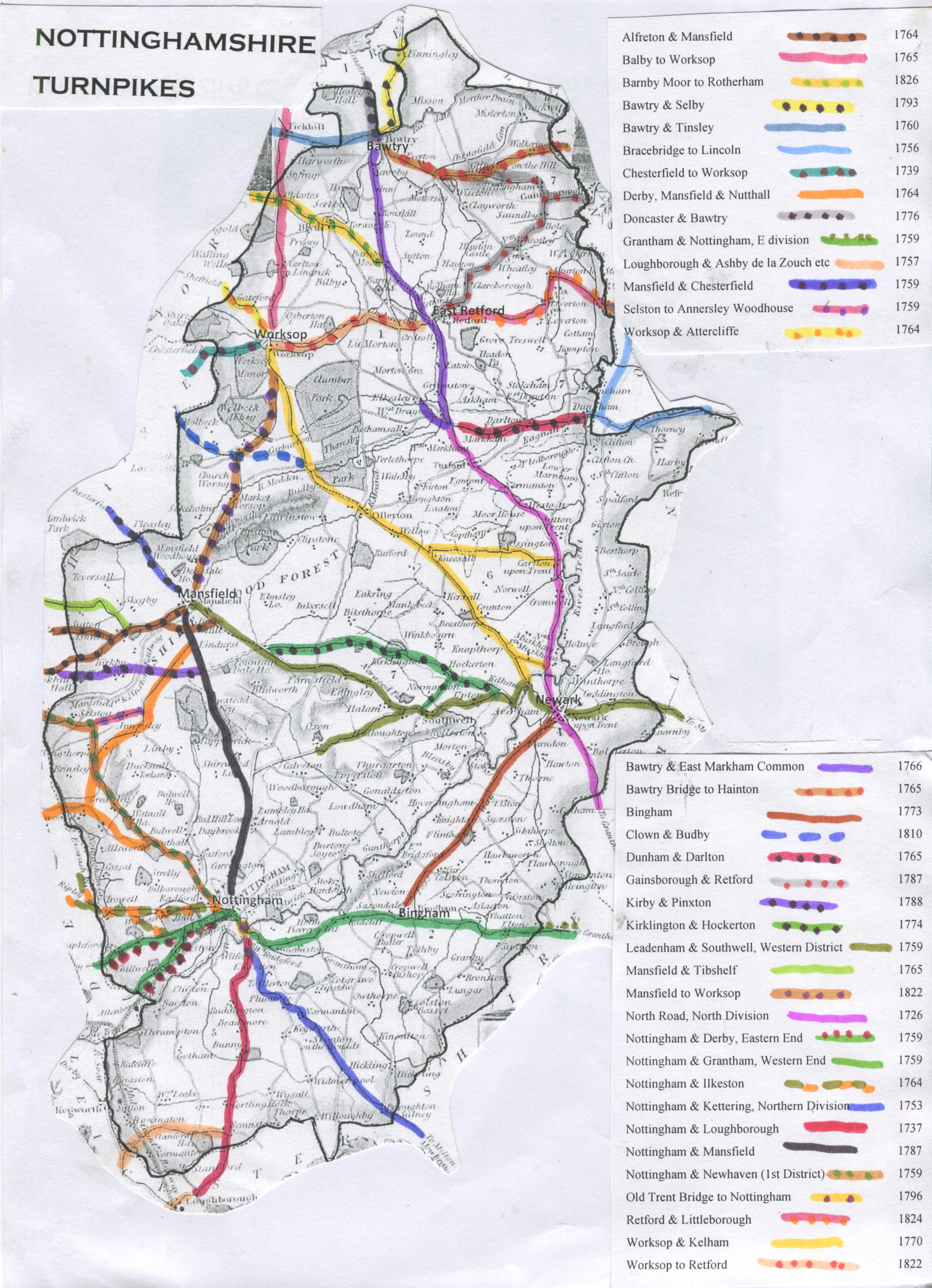
Having kicked off the idea of it being a turnpike term, I am now worried if ever there was a turnpike along there. When Byron was buried at Hucknall, his funeral route from Nottingham allegedly went up the Mansfield turnpike and through Papplewick, because there was no good road from Bulwell to Hucknall. This list is all I could find - and it seems unlikely to me that any of these passes through Bulwell? http://www.sabre-roa...shire_Turnpikes
This map
http://www.turnpikes...e turnpikes.jpg
suggests that the road from Bulwell to Basford was off the turnpike system altogether.
This gives a complete list of tollhouses in the county - Radford and Bobbers Mill are the only ones even close by, as far as i can see.
-
This map
http://www.turnpikes.org.uk/map%20Nottinghamshire%20turnpikes.jpg
suggests that the road from Bulwell to Basford was off the turnpike syestem altogether.
This gives a complete list of tollhouses in the county - Radford and Bobbers Mill are the only ones even close by, as far as i can see.
http://www.turnpikes.org.uk/Tollhouses%20of%20Nottinghamshire.htm
-
Having kicked off the idea of it being a turnpike term, I am now worried if ever there was a turnpike along there.
When Byron was buried at Hucknall, his funeral route from Nottingham allegedly went up the Mansfield turnpike and through Papplewick, because there was no good road from Bulwell to Hucknall.
This list is all I could find - and it seems unlikely to me that any of these passes through Bulwell?
http://www.sabre-roads.org.uk/wiki/index.php?title=Nottinghamshire_Turnpikes
-
There are a numbers of Catchem/s Corners in the country, including Wolverhampton and Stoke. I think the name derives from nicknames for tollgates on old turnpike roads. The toll fee was collected by a tollgate keeper for most people wagons etc passing through - they would 'catch'em' for the toll.
-
The map shows just how impractical the street layout was in older times. Getting through town to Trent Bridge must have been a nightmare.
-
Your best bet is to wangle your way into a flat in Meacham Court, a highrise just off the High Street Battersea, close to the Castle pub. You would then get views like this, almost the same viewpoint as the "Nottingham" photo

High Street is the road running left to right, with the pub just below us. You can see one of the chimneys of Lots Road Power Stn on the right.
On the far side of the High Street (partly obscured by scaffolding and plastic sheeting) is the remaining 2/3 of the 3 storey houses in the middle in the "Nottingham" photo
-
That really clinches it for me - the only problem is your X on the first photo is too close to the river. If you look at the "Nottingham" shot, the viewpoint is almost in line with the 2 RH chimneys of the power station. That would make the profile of the large building on the right more side-on.
Of all the roads in the area, the northern half of Battersea High Street is the only one on the right alignment. It also curves the right way. As I mentioned in a previous post, 2/3 of the 3-storey buildings in the middle of the "Nottingham" shot are still there if you look on Google Streetview - though little else has not been replaced.
-
A view of the church spire from the other side of the river
note the tall chimney to the right, which appears above the house rooves to the left of the spire on the original "Nottingham" image
Also this shot, taken from further down the same road as the "Nottingham" shot (nearer the power station)
http://www.flickr.com/photos/34794537@N02/5427808500/
The roofline of the power stn looks a bit shorter in this shot, because originally it had an overhanging structure at roof level at each end.
This shot (looking the other way up the High Street) may possibly show the building the photo was taken from at the far end on the left
http://www.flickr.com/photos/34794537@N02/5777723775/in/photostream/
-
Is that off lavender hill ?
Not quite - Battersea High St is slightly further north and much closer to the river.
-
I looked on Old-maps.co.uk. If you type in the coordinates 526959 176482 and look at the 1:1,056 map for 1906-1919 you can work out the building the shot was taken from. It was the Southlands Training College for Girls, near the bottom of the screen, looking north along the High Street. The garagge is the recessed building opposite R in Street. The other buildings nearby all correspond very well.
A view from there would definitely show the power station, the other tall building on the south side of the river and the steeple of St Mary's Church. This has to be it, surely?.
-
My best bet is Battersea High Street.
Not much left after the Luftwaffe and local authority set to work, but a couple of tall old buildings on the left of the road in streetview look like the end of the tall block on the left of the original photo.
The way the road curves ties up with the photo too.
-
This image shows a building - see across the river from the power station - that might be the large one on the right of the original image
http://www.britainfromabove.org.uk/image/epw006137
There is a church with an ornate tower next to it.
-
This photo shows how Lots Road towered over neighbouring buildings. If my guess and my bearings are correct, our mystery street would be roughly in line with the pair of left-hand chimneys, heading across the river.
http://www.britainfromabove.org.uk/image/epw006134
My guess is based on the distinctive overhanging bit on the left hand side of the power station, which seems to appear on the right of the power station in the original photo.
-
A couple of points - I doubt this is a main road, as by 1911 there would likely be trams and lots of other traffic. I would imagine a side road of some kind. Also, if my theory about it being Lots Road is correct, the view may be from south of the river.
-
I would think Lots Road Power Station near Chelsea is a reasonable possibility, having looked at a few more photos.
This one http://rbkclocalstudies.files.wordpress.com/2012/03/lots-road-power-station-1921.jpg shows 4 chimneys, a featureless roof and a bit sticking out on the right, with a hoist or conveyor sloping steeply down to the right of it. On our photo, there is an identical feature. The proportions of the whole building and the chimneys is about right too. If so, then we could be looking across the Thames from the Clapham/Battersea area.
Greenwich power station was very similar in appearance, but I can find few good photos of it.
-
Many large power stations were quite late - even post-ww2
One possible London candidate for the one in the photo is Lots Road opened in 1904 - see http://www.guerrillaexploring.com/gesite/public_html/index.php?option=com_content&view=article&id=42:ges003-lr-power-station&catid=4:industry&Itemid=5
-
Wilford Power Station wasn't opened until 1925 - see http://nottstalgia.com/forums/index.php?showtopic=5806#entry72233, whereas the street scene looks pre-ww1 at a guess? Also, the roof looks a lot less tidy that the one in the above photo.
I would still put my money on it being somewhere in London
-
Maybe a spelling error - Mottingham?

-
I'm no expert, but those flat rooves shout 'London' to me.
When there were blue buses
in Pete's Nottingham Transport Forum
Posted
There was one inbound on Vernon Road Basford, just before Valley Road.