

notty ash
-
Content Count
603 -
Joined
-
Days Won
4
Content Type
Profiles
Forums
Calendar
Posts posted by notty ash
-
-
Looking at old maps, St Albans Road existed as a trackway from Bulwell to Park Lane, even in the 1880s, before the GCR or the GNR Leen Valley line were built. The GCR was famously built without level crossings - the last one on the line to London was at Beighton, just east of Sheffield. This map of 1900 shows the situation immediately after the GCR was built. The line in orange is an old trackway or path from St Albans Road to Hucknall Road which was closed when the GCR was built, by the look of things. The new bridge over the GCR was midway between the Hucknall Road end of Park Lane and the trackway from St Albans Road to Hucknall Road, replacing both.

The two dots show the position of the bridge under the GN Leen Valley line. Older maps show there was a farm gate here before the GN line was built. I assume the bridge was built to maintain the access to the farm that the gate had previously provided.
Hucknall Lane did continue north towards the River Leen, but seems to have been little more than a trackway itself at this time.
-
Click on the close button at the bottom left of the map. This brings back the index map. You can then click on a new central point and choose the map you want to browse from the list on the right. It is a bit long-winded, but with a bit of practice it becomes quite easy.
-
Possibly the same block of flats I referred to in my post here...last paragraph post 1
That sounds very likely.
-
The best way to browse the area is to use http://www.old-maps.co.uk/index.html. This enables you to scour as big an area as you like and over a number of years.
Unfortunately, it doesn't recognise Basford, but type in Bulwell or Radford and work your way around from there. Alternatively, key in coordinates 455453 and 342764.
There is a 1:500 map of 1882 and various 1:2500 maps up to recent times.
-
Thanks for the idea of the building I queried being flats. It certainly makes sense as they are definitely linked to the grounds with the gas holders on. Here is a larger plan from the 1:500 map

-
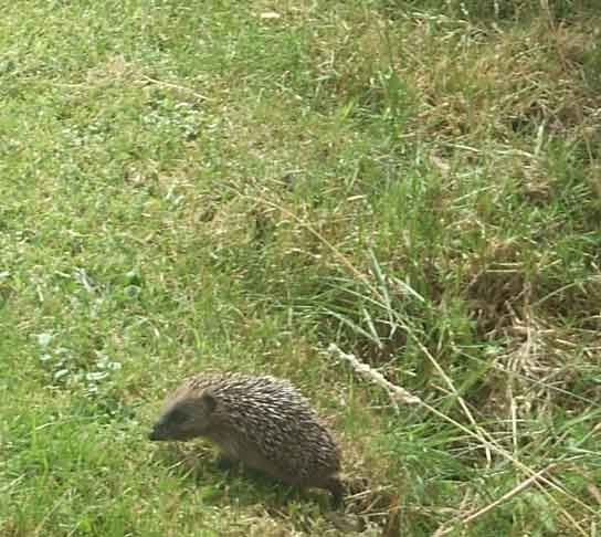
The baby hedgehog turns out to be two!
This one was out hunting around 2pm in the back garden.
When I returned from shopping an hour later, this one was in the front garden, at the side of the house
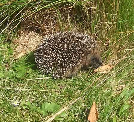
I saw another one from the kitchen window. I thought this was the same one, out back - but quickly checked and the one in the front garden was still there......
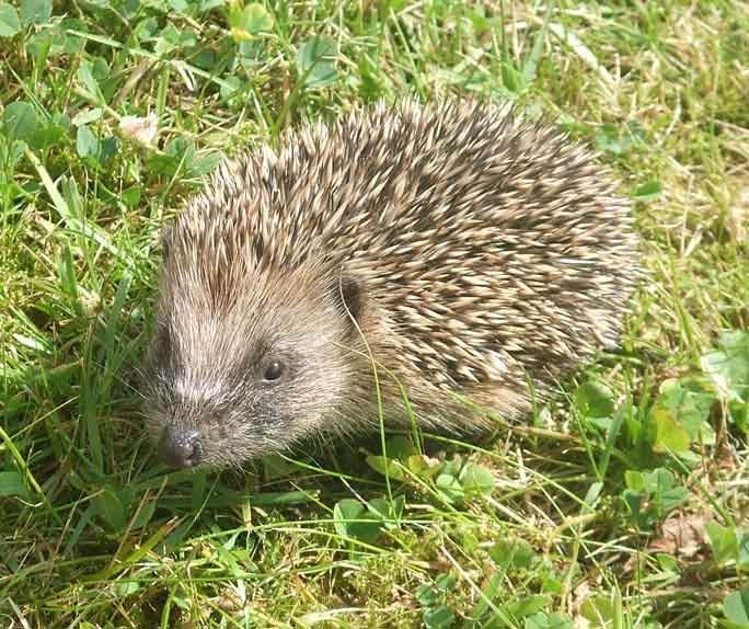
I got up really close - I think I even got a smile

-
 2
2
-
-
Out of sheer curiosity, does anyone know what the odd-looking building opposite Scotland Street and jut above the gas holders was (with 348 next to it). Looking at later maps, it had gone by 1900.
-
Some local photos of the lightning (and other areas too) here
-
Interesting that there was a gated road leading north next to the railway - looks like it was originally the entrance to the station goods yard and only continued a short way north.
-
Last night was the most spectacular north of Nottingham, with a huge storm passing over around 10pm. There were flashes every 30 seconds or so at times - most in the clouds rather than towards the ground. Some of the horizontal lightning was very spectacular indeed. Impossible to photograph as it happened so suddenly and unpredictably!
-
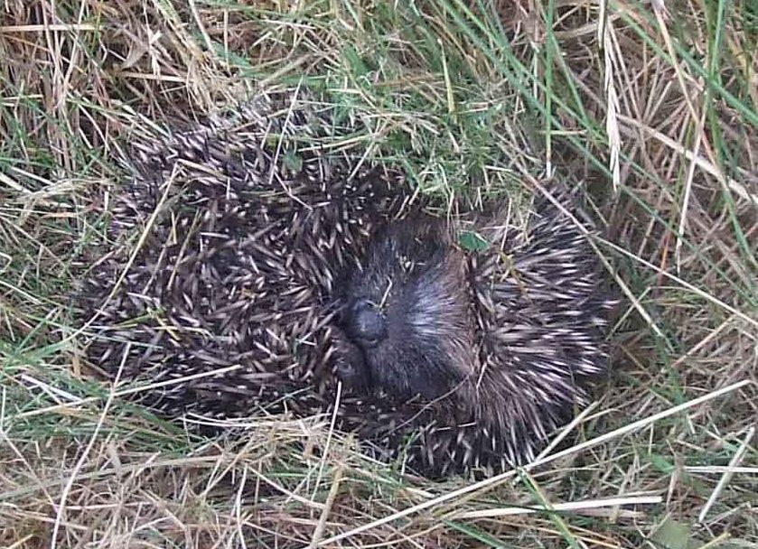
Found this little cutie in a corner of my front lawn this evening - fast asleep and totally oblivious to me mowing the lawn. Definitely very much alive!
-
3
-
-
Who's the Jessop who has a monument in his/her honour? It's not the retailer who sold out to John Lewis is it?
This was William Jessop jr (1774-1852), a major partner in the Butterley Company of Ripley who lived at Butterley Hall. He was the son of William Jessop sr. who built lots of canals and was a founding partner in what became the Butterley Company.
-
That plaque was second hand - moved when a house was demolished (rumoured to be from Huthwaite)
The highest point in Notts is Newtonwood Lane near Silverhill, with Silverhill woods a close second. Strawberry Bank in Huthwaite is a close third. - all just over 200m.
See http://www.bbc.co.uk/news/uk-england-nottinghamshire-13630511
-
My guess is that "Marble Arch" and similar bridges date back to the building of the railway line.
I wonder if the name came from bus conductors labeling it to give the bus stop a name, what else could they call it?
The topography of the spot means that bridges would have been built when the lines opened. The original bridges were definitely rebuilt when the roads were widened just before WW2. The 1:2500 OS maps clearly show narrow bridges up to that time and much wider ones thereafter (except the bridge on the south side of Hucknall Road, towards Basford, which did not change). Could "marble" relate to the gleaming new concrete construction - when new, it would have been quite a contrast to the old, smoke-ridden brick structures there before?
-
Thinking more about "Marble Arch" it must have been there before Bestwood Estate was built, other GNR bridges were also red brick, they did not wear as well as the Blue brick ones. I presume there was a farm originally when the bridge was built.
Looking at OS maps, there were always bridges at this spot. I suspect they were rebuilt around the same time as Moor Bridge (1938-9) as part of a major upgrade of Hucknall Road and Arnold Road.
-
The walkway goes all the way to Hucknall (to where the line to Calverton branched off), then continues from Linby to Newstead. Further on (after a long gap) it continues from Sutton to Pleasley and Teversal.
-
Tripehound is in dictionaries, so probably not confined to the Nottingham area. It means - a good for nothing or objectionable person.
-
A hedgehog appeared in my front garden around 4:30pm this afternoon, looking quite well-fed.
Totally oblivious to all the kids playing in the street, just a few metres away.
-
I didn't plan the 50 mile one - it just happened!
I started by out walking from Ashfield to Southwell - but it was such a nice day I felt up for it, so I just kept going and going. I was out for 15.5 hours in the end.
I ended up walking across to Fiskerton, down the Trent to Carlton, across to Arnold then through Rise Park (it was dark by then!) to Moor Bridge. I followed the main road up through Hucknall and Annesley and back home to make sure I was under street lights as far as possible.
If it were all in daylight I would have gone a more picturesque route back.
-
I go walking to keep fit, get lots of fresh air and explore the local area. It is only in the last few years that i have taken it really seriously. I now regularly do 20, 30 even 40 miles sometimes and one just over 50 miles recently. I've never been so happy in all my life.
-
1
-
-
The best rail solution for Nottingham would have been to scrap everything and start again
It would have been far too expensive though!
Neither Victoria, London Road or Midland were ideal - either in location or routes. Nottingham City Council was at least partly to blame. In the 19th Century, they made it difficult for the railways to build anything too close to the city centre, or that might cause any "obstruction". The original plan for the Great Northern was for a railway line from London Road across a viaduct past the castle and out to the west. Instead, the objections of the council forced them to build a long loop round via Gedling and Arnold.
It was only when most of the lines had been built that the council realised the error of their ways and tried to persuade the Great Northern and Midland railways to develop a central station - but to no avail.
Finally, the Great Central built its line through Victoria, but with poor connections to the west.
Victoria was a grand station. If it had survived, it would surely have ended up looking like Birmingham New Street though - a concrete tunnel under a shopping centre. It suffered from having just 2 tracks at either end - the ones to the north being quite long and very expensive to widen.
-
East Midland used to run lowbridge buses on the 12A from Nottingham to Chesterfield. We used to go on top, just for the novelty of it. Not sure where the low bridge was on that route, unless it was one of the railway bridges at the bottom of Nottingham Road in Mansfield.
-
1
-
-
NCT got around this problem with the "J" registered Atlateans, they were lowbridge but without lowered gangways or long bench seats. I don't know how they did it but it was someting to do with "dropped axles"? Perhaps someone with technical knowledge could help here?
This article explains everything
-
Simca and the Rootes Group (Hillman, Humber etc) became the European division of Chrysler, which then became part of Peugeot
Hucknall High Street 60s/70s
in 70's Nottingham
Posted
If I remember correctly, it was a typical old-fashioned car showroom with workshops at the back. They completely rebuilt it in the early 70's (?) but it never reopened. The new building eventually became the Yorkshire Bank.