

notty ash
-
Content Count
602 -
Joined
-
Days Won
4
Content Type
Profiles
Forums
Calendar
Posts posted by notty ash
-
-
I was walking through Kirkby on Monday night, well after midnight (don't ask) and saw a hedgehog gradually working its way along Lowmoor Road, sniffing at everything it passed.
We had one in the garden every night for several months a few years ago. It had a regular round, patrolling my garden and others along the street. You could almost time it by when dusk arrived. One lunchtime, I saw it in the back garden in broad daylight, in the summer.
Then all of a sudden, it just never turned up again - run over or died, I guess

-
The term 'King of the French' is fairly specific in official terms
Used by Louis XVI from 1791 to 1792, and by Louis-Philippe of France from 1830 until 1848.
I suggest the second is the most likely - known as the Citizen King - and the last truly royal monarch of France.
Other monarchs specifically used the term King of France or other titles
-
I think the general rule is that water for public consumption has to be protected from risk of pollution once it has been treated. That is why public water reservoirs like Ladybower are open, whereas ones nearer the point of consumption are buried.
Most open reservoirs in the Nottingham area I can think of were canal feeders - the ones at Butterley and Ironville are two other examples, or water management systems for things like mills - like Kings Mill near Mansfield - and water meadows.
-
Moorgreen Reservoir was built to supply water to a canal - the Nottingham Canal, if I remember rightly, which ran along the Erewash Valley from Langley Mill down to Nottingham
-
I looked on the Old-Maps.co.uk site.
I can't argue with you about the headgear, but all the buildings, field patterns, roads, stream, railways etc fit perfectly. The curved railway siding in the near foreground and the pavilion on the sports field seems to have been quite late additions - maybe late 1930s or later.
The curved railway siding is odd - very expensively engineered for a mere siding. I just wonder if it had any role in the modernisation of Hucknall Aerodrome? It is certainly heading in the right direction, though the only maps showing it suggest it only went just beyond the edge of the photo.
-
I would suggest the railways around the pit are completely wrong for bottom pit - and the town centre should be much closer, on the right.
I would go for top pit. The farm (Shortwood Farm) in the foreground is in the right place and the curved railway line just beyond it does show on later maps in the mid-1950s. They also show tips in the places shown on the photo. There is a small quarry on the opposite side of Watnall Road to the pit, in the large field with a sports pavilion, also shown on OS maps.
The airfield, even in its later form would be off the picture to the left. Even the Ruffs Estate would be off the picture.
The huge field of allotments in the distance are in the right place and the right shape for No1 pit too.
The only puzzle for me is that Long Hill Rise doesn't show - apart from maybe a few houses at the extreme right of the photo. That might be a good way of dating the photo.
-
Some of the later AECs had a half-cab and front doors behind the engine. They must have been just about the last front-engined buses bought by NCT?
-
I have enjoyed a number of very interesting walks by the Trent. All the way from Ingleby in the south to the Humber estuary, there are lots of viewpoints and interesting things to see - though probably not all on the same walk!
The only real disappointment for me was a trek, generally along the west bank, from Nottingham towards Newark. I got to Kelham and found the footpath stopped abruptly at some private premises with signs telling everyone to head off across the fields to the nearest road. I believe there used to be a ferry crossing there at one time, so walkers could swap banks and continue up to Newark.
-
 1
1
-
-
My gran used to call the local Co-op store the "Kwarp"
-
New cars were very difficult to get hold of immediately after the War due to the government's export drive. It is most likely a new body on an old chassis - in the days when almost all cars had proper chassis and there was no MOT, so a plentiful supply.
Alternatively, it could be an early prototype of one of these
http://en.wikipedia.org/wiki/Volvo_480

-
The more I look at the image the more I think how wierd it is. Apart from a few styling features it looks nothing like any car of 1950. No mudguards or wings, bizarre headlights projecting out from the bonnet, wrap-over side windows (?)
It looks very home-made to me. Maybe it is one of those concept cars, guessing wrongly what cars would look like in the future - or from the film set of a cheap British 1950s prequel to "Back To The Future"
-
I found this link which shows the routes of railways west of the Annesley Tunnels placed over a modern map - hope it works!
-
This site is very useful for cars available in particular years and photos of them.
http://www.uniquecarsandparts.com.au/car_spotters_guide_europe_1950.htm
Just change the year in the box near the top to see other years
-
Also, the Allards all have separate bonnet and wings - the car in the picture does not, or they are not as distinct. The geometry between the bonnet line and the lower edge of the door windows also seems odd.
Agreed it is not too obvious, but there is a definite hint of the bonnet and wings being separate. It is just a shame the sun was so strong and washed out a lot of the detail.
If you look in my compilation below, I show the original photo in the middle, with a shadow ringed in white hinting at the line of the bonnet.
Above it is a mirror image of the estate car I showed earlier, with the headlights moved to roughly where the ones on the Nottingham photo are.
At the bottom is the earlier (1950ish) Allard windscreen. These earlier Allards had a very bulbous waistline too which is evident in the Nottingham photo.
To my uneducated eyes it does look a bit like a combination of Allard features from different models - maybe a prototype, or a kit car lookalike? I know cars from the 1950s moderately well and can't think of anything else remotely similar.
-
I was thinking Allard too, but can't find a suitable model. It does have a lot in common with the Safari 1952-1954 model seen here (from http://www.cartype.com/pages/290/allard_brochures)

but the rear roofline of the car in the Nottingham photo is not long enough to be an estate car.
-
The RCTS mystery photos site also has lots of photos of the Nottingham area
http://www.rcts.org.uk/features/mysteryphotos/
You need to do a search on each location you are interested in, which can be quite laborious, but there is a wealth of material there.
-
1
-
-
For anyone interested in photographs of trains around Nottingham, this topic on RmWeb has some very rare images, mixed in with photos from other locations.
-
1
-
-
The days when you couldn't move in north Nottinghamshire for railway lines. The present Robin Hood Line is the curvy track going from the bottom of the map to the top.
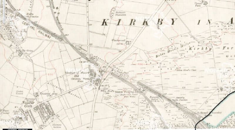
Sorry for the late comment, but I have only just noticed this topic.
The Robin Hood line actually follows the northern edge of the Great Central and then Great Northern lines round to the present Kirkby station. The trackbed of the old Midland line beyond where the Midlan crossed the MS&L tunnel is now a footpath most of the way to Kirkby town centre. This section of the Rbin Hood line was a brand new railway, built specifically for the Robin Hood extension from Newstead to Mansfield Woodhouse. Just south of Kirkby station it joins the former GNR line bypassing Kirkby town centre.. Just before Sutton Parkway it takes a sharp S bend to rejoin the old Midland route to Mansfield.
The area just to the west of the map shown here is far more complicated, with 7 railway lines and several colliery sidings all intertwining. The Midland and Great Northern lines were linked in the 1970s to provide a route towards Pye Bridge for coal trains avoiding the notorious Midland level crossing in Kirkby.
-
The Bulwell Hall terminus was just north of Longford Crescent, about one third of the way towards the roundabout for the Hucknall bypass.
I used to live just up from the terminus and still remember the trolleybuses with great fondness. We used the 44 regularly to travel into Nottingham, sometimes changing to the 43 at Bulwell market place for a through ride to Trent Bridge. I remember trying to persuade my parents to take me all the way to Colwick on the 44, but never succeeded.
The conductor had to use a machine on the pavement at the Nottingham Ring Road stop at Basford to record the time they arrived, if I remember correctly. I can still clearly remember the smell of the gasworks we passed a little further into Nottingham.
-
If you look at the path of the Great Central line between Carrington and Wilford, it does seem to veer quite a way east of what would have been the direct route. The Theatre Royal site, or maybe the next block west, would have been more direct. Maybe the Council did influence the site of Victoria station, which gave a far less obtrusive route through the city centre.
Looking at the whole route from Annesley to Ruddington, it showed a willingness to use a succession of expensive engineering solutions to overcome the obstacles.
-
1
-
-
The Belle View reservoir between Mapperley Road and Woodborough Road used to be very good - and not well known, but I haven't been up there for many years now.
The best approach is from the very top of Huntingdon Street - there is a path up the hill at right angles to the road.
Hedgehogs
in Owt' Abaaht Nowt !
Posted
I suspect it was just hungry - not much darkness in the summer to gather food! It was just sniffing around the back garden like at night. It was around for a while after that.
It was pretty safe in my back garden - the cats found it difficult to get in.