

Cliff Ton
-
Content Count
14,723 -
Joined
-
Last visited
-
Days Won
209
Content Type
Profiles
Forums
Calendar
Posts posted by Cliff Ton
-
-
Thanks for that......
I searched it, and got a downloaded PDF of it which I'll be reading in the next couple of days
-
Thanks for that. Seems like a herd of country bumpkins running around chasing each other

I suppose that's what people did before the internet was invented.
-
Various photos of it crop up in several railway threads here. Trying searching "Valley".
Otherwise, your best bet is to go to Picture the Past and search "Valley Road". That will give you a lot of options, showing the original early bridge and the later 1920s enlarged version.
-
I dont think where the COOP was located was over the track. I could be wrong?
I think the track was below the new building on parliament street next to the dog and bear pub?
This is the scene before any of the supermarkets were constructed. The small chalet-type place with an arched roof (between all the white posters) was an entrance to Victoria Station, and the railway lines were below it
-
And this from the other side, after the station had gone
-
And the Shepherds Race.Another historic site nearby.
I've heard of it and I know there was/is a service station of that name. But what's the history?
-
Ah ! Now it makes sense. The Walter Fountain. Used to be on Lister Gate outside Woolies.
http://www.pictureth...008371&prevUrl=
Pic the Past has quite a few photos of it
-
 1
1
-
-
The real Well, which the area is named after, doesn't seem to have been mentioned in these forums. Difficult to imagine going there today that it used to be a place which had special religious, magical, healing significance.
But somebody's going to have a look http://www.bbc.co.uk...mshire-16654628
More likely to dig up a few old needles, abandoned cars and phones.
-
looks like the boots shop that was built on parliament street where the old entrance to victoria station was? have a look at picture the past
I reckon that's it. This shows what was to the right of it http://www.pictureth...017402&prevUrl=
Where Wilkinson is now ?
No, other side of the road opposite Wilko
-
Taxi Ray is right on that one. The building wasn't M&S back in the days of the original photo.
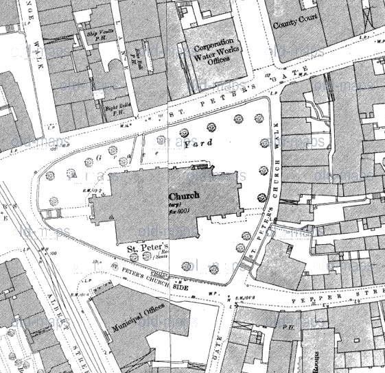
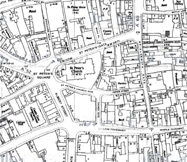
Here's a closer and earlier map (1880s) which shows it clearly marked as Municpal Offices.
And on the subject of Water Works as mentioned by mgread1200, note the building on St Peter's Gate which is marked " Council Water Works Offices". So there's a water connection, but not exactly a water works.
-
Re: the St Peter's M&S photo
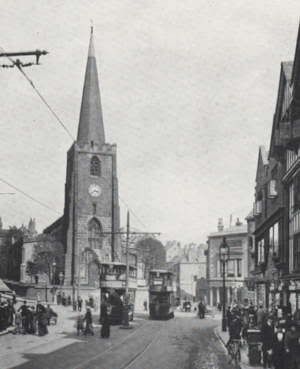
In those days there was a road between the church and the M&S building called St Peter's Church Side. That continued on to Pepper Street which came out on Bridlesmith Gate. That was all closed off when M&S expanded in the mid 60s.
You can also see St Peter's Church Walk behind the church - which is still there but not a through route - and Church Gate which went through to Low Pavement.
M&S built over a lot of thoroughfares back in the 60s.
-
Also......... is there a quick and simple way to find out exactly who has hit the "Like" button on a post?
I've got a few "Likes" and I'd be interested to know where I got them, and what for. But the only way to find out seems to be to trawl through every topic........which I ain't doing
-
1
-
-
Napoleon XIV - They're coming to take me away
-
And your photos came in folders like this
-
1
-
-
I think it's the top of King Street, like this http://maps.google.c...,81.05,,0,-3.81
-
For a slightly later version of that picture - and more, take a look at this http://www.gcrleices...nottingham.html and scroll down after the first half-dozen photos
-
1
-
-
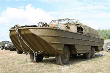
I remember at Ingoldmells there was an "Amfibious Duck" they took folks out on, Dad would never let me go on that, Mam once told me it reminded him too much of the "beach heads" during the war. Nobody deserved those holidays more than them.
I remember them, the beach was full of them in those days. Do they still operate?
Ex-WW2 landing craft.
-
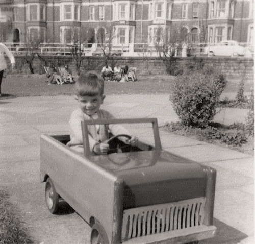
Me driving at Skeg, early 1960s
-
The city side of the canal is quite decent these days. But over on the other side of the water you have the Magistrates Court, and the area outside there is usually spoiled by the gathering of chavs and pond life waiting for their turn to appear in court.
-
I never knew Bulwell in the days when it was full of railways so it's fascinating to see all those places. It's like seeing all the still photos on Nottstalgia, but moving.
And if you play it right through to the end, check out some of the other videos which are "advertised"
-
Bit of a coincidence, but..........http://www.bbc.co.uk...mshire-16579374
-
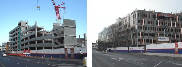
Back to the other ugly building - the new station car park - I took a photo of it before it was "decorated".
It looked slightly better when it was being built than it does now it's finished.
-
Aha! Greyfriars rings bells. I used to go there from my workplace at the time (Miller Bros) and enjoy a chip lunch once a week.
Greyfriars was also the name of the school in the Billy Bunter series. Maybe there was a connection between his size and the number of chips involved
-
I think they went the same way as all of the small/medium stores.........they couldn't survive in a world full of Sainsburys and Tesco and Asda.
It's quite a list when you think about it....... Marsdens and Farrands and Lyons and Burtons and the others you remember when you were a kid
St Ann's Well
in St Anns, Sneinton & Colwick
Posted
This is the link I've used http://www.lulu.com/...mitage/17465973 which gives a free PDF of the book
It's mentioned in the book above, with a diagram. Just slightly south of where the Gardener's pub was