

Cliff Ton
-
Content Count
14,713 -
Joined
-
Last visited
-
Days Won
208
Content Type
Profiles
Forums
Calendar
Posts posted by Cliff Ton
-
-
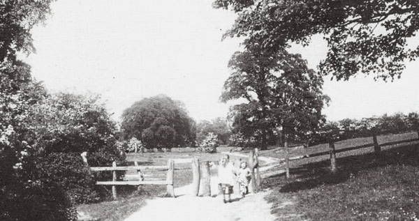
And another branch of Day Brook..........I found this http://www.pictureth...017816&prevUrl= on Picture the Past
I haven't yet worked out where the Brook is on that photo, but I'm intrigued by Farrand's Mill. Would that be connected to the Farrands with the grocers shops, who get a lot of mentions on these pages?
-
I was guessing the location of the house in the photo was.....if you go straight up from the word "pond" you can see a driveway (dotted lines) pulling up outside the white shape which I took to be the house itself
Unless, of course, it's a completely different house altogether and I'm looking at the wrong place

-
There was another thread which got sidetracked onto this topic, but I reckon it deserves a heading of its own
Was/is there a 'Day Brook' running through DayBrook???
Still there, but well hidden and sometimes underground
With regard to the Daybrook..Early last century this pleasant looking mansion was on the site of the Five Ways pub, with a small lake in front fed by the brook.I forget who owned it,but I've got the info somewhere.
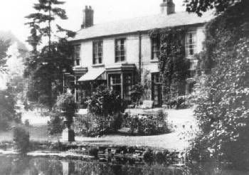
Poohbear, The house was "Daybrook Vale" belonging to Charles J Mee, nurseryman.
The brook used to run through a tunnel near the Five Ways pub.
So to understand it all in one go, here's a map of the area back then.
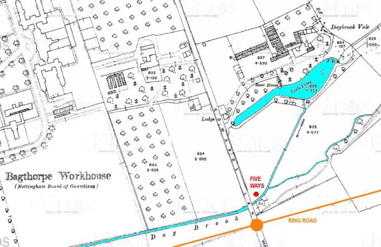
Daybrook Vale - the house pictured above - clearly has its own grounds and pond and boat house, and what seem to be gardens/nursery. And they seem to have connected the Day Brook to their fish pond.
For anyone who doesn't know....Bagthorpe Workhouse forms the basis of City Hospital
And finally, here's a photo which says its "Daybrook Vale", although I don't know exactly where. Looks like a nice place though; certainly won't find anywhere like that now
-
 2
2
-
-
If you haven't already checked it, both "Sunnyside" and 'Ghost House" are clearly marked on the 1885 version of Old Maps.
-
other old quarry/brickworks evidence can be found in Winchester St.
Like this at the top of Woodborough Road. http://www.pictureth...003328&prevUrl= Looking at the area today it's difficult to know this ever existed
theres still walls of a bridge on it where a cable hauled railway ran under it,
And another here at Sherwood Station. http://www.pictureth...000431&prevUrl=
If you follow that line on the right, it eventually goes under a small bridge on Mapperley Rise/Winchester Street which still exists
-
1
-
-
Looking at a map of the area in those days, that is almost certainly the rathole you went down. Coming off the GN line and onto the GC. If you use the search function on this forum and put in the word "Rathole", you'll get thousands of results which will include quite a few photos of the hole.
-
flat bridge as it did not have to go over tracks and so would not show up on long distance photos?
Not exactly brilliant, but the best I've found........ you can just see the Signal Box and the Suburban Line going off to the right
-
1
-
-
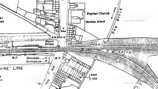
On the extract of the map, of the railway, what does M.P and S.P mean, it is probably very obvious but I cant seem to work it out.
I have a copy of the old Arnold and Daybrook map from the turn of the century, it is surprising how rural Arnold was it was mostly surrounded by open countryside.
Mile Post (ie distance from the nearest main "base", presumably in this case Nottingham) and Signal Post (a signal to normal people)
-
No compo looks like it was before "our time", the "bridge" I referred to was to the east of the junction. From what I gather after the lines parted as in your photo the NSR one ran on an embankment (maybe the GNR one too?) and there was a walkway type of bridge across the "Y" as it were near to/from a signal box that was on the GNR route,
I reckon you can see most of those elements here........
-
Some fantastic photo's - particularly the one of Victoria being demolished that Cliff Ton posted.
Where did that come from Cliff ?
It's taken from this book http://i954.photobuc..._2010/book1.jpg
Not sure if you can still buy it anywhere
-
Remember it well. Walk along it and you disappeared in a cloud of steam as a train passed underneath.
It's been mentioned before, with quite a few photos http://nottstalgia.c...ia&fromsearch=1
-
I remember the parcels thing, but apparently it went on for longer than I remembered.
According to the PtP info on this photo http://www.pictureth...008355&prevUrl= it was doing parcels until 1988
-
You are probably thinking of Nazareth House near Abbey Bridge. It closed down a few years ago and the site is now occupied by housing, although I think some part of the old building has been retained and worked into the new parts.
Again, Lenton Times have quite a lot of information on the subject http://www.lentontim...areth_house.htm
And Hooley's commercial garage disappeared at least 10 years ago, or maybe even longer.
-
1
-
-
Funny how everybody here is referring to it as "Parker's Cafe", which it still was when the Streetview cameras went past. Everybody seems to know it and where it is, but has anybody actually been in it?
Apparently it is now called "Kelly's Cafe" and has been for a couple of years.
-
According to the Disused Stations site - Arkwright Street closed with the country stations on 4th March 1963 but reopened on 4th September 1967 as the terminus of the line from Rugby following the closure of Nottingham Victoria. It remained in use until closure of the line on 5th May 1969, The station and viaduct were demolished early in 1975
-
1
-
-
A game we called Kerbie
Hedge hopping
Kids still play kerbie everywhere today. Amazing that in the days of Xbox and wii, simple stuff like throwing a ball at the kerb can still keep them amused for hours
I'd forgotten hedge-hopping but now it's been mentioned I remember it. Used to happen all over Clifton because all the houses had privet hedges so it was easy to just jump/roll over them into the gardens. Only ever done at night when it was dark, and even then the trick as to get away before anybody looked out of the window
-
According to Cliffs Posted image The land was allotments.
Are you sure the PtP image is not the corner of Warwick Street with the allotments behind the fence extreme right?
Mick, I think the houses you see on that photo are Warwick Street.
Looking at this photo http://www.pictureth...018795&prevUrl=
....the small odd-shaped building on the right is still there today, and immediately behind it is/was Parkers cafe. And the wire fence on the right is the same fence on the photo with the cyclist
And here's today's equivalent view
-
The Fire Station (now closed), Parkers Cafe and PDSA are fairly new buildings, poss early 60s?
What was there before then?
Nowt really. On this..... http://www.pictureth...018798&prevUrl=
....the space behind the white posts is where the fire station would later be. The ring road towards Clifton would go up behind where the cyclist is
-
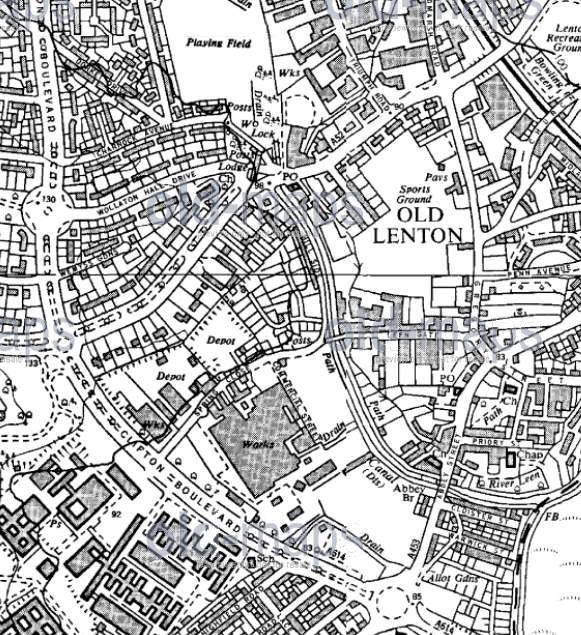
On the map that Cliff ton has shown, Abbey bridge is marked as being roughly opposite where the Johnson arms is now, is this a mistake or was there an earlier bridge of the same name.
This would be a bridge over the leen, and the other Abbey bridge is over the railway line.
Looking at the Old Maps site, the bridge at The Johnson Arms is always referred to as Abbey Bridge. The name for a bridge at that location must go back several hundred years when it would've been a bridge over the old River Leen alongside the original Lenton Abbey.
The Leen ran along one side of the Johnson Arms and the Nottingham Canal ran on the other side; I reckon the two waterways have been merged into the one which exists now
The other Abbey Bridge - the railway version - is a later addition, built in the 1920s.
-
Here's a map from the early 60s which will answer most questions about Spring Close
And a couple of photos of it
-
1
-
-
The area which is now occupied by QMC was known as Spring Close.
Lenton Times have quite a few photos of it back in the old days, including some of the companies you mention http://www.lentontim..._close_area.htm
They also have photos of the Mk1 and the Mk2 versions of the Dunkirk Flyover
-
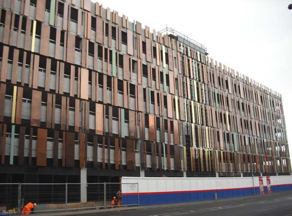
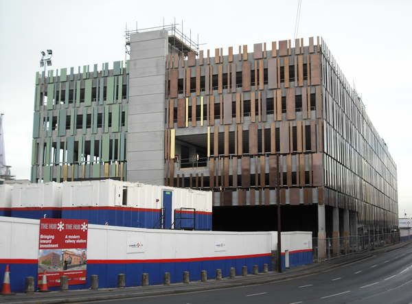
For anyone who hasn't been in the area recently, there will soon be a new multi-storey carpark on Queens Road (down the side of the railway station) for rail users.
I'd been past the place a few times whilst it was being built and it looked like any old multi-storey car park.
Now somebody has been along and stuck metal bits all along the sides. Is that an improvement? Or is it the new Contemporary?
-
Slight variation on that one of walking around........I remember kids would do it to start a game of football and they'd wander round chanting/asking for volunteers for the two sides in football.
Problem is....they'd take so long to go round getting the players that the match itself only lasted a few minutes before playtime ended and everybody went back inside. Then the whole process would start again at the next break for another 3 minute football match
-
The name Black Boy did get used for a place at the top end of Market Street in the late 70s/early 80s
This http://www.dreamtarg...allery_0046.htm makes a reference to it
And look about 5 paragraphs down on this http://www.thisisnot...tail/story.html
Railway Photos
in Pete's Nottingham Transport Forum
Posted
I recckon the Bestwood part is shown as "Coming Soon to this area".
Looking at the Old Maps site, Longmead Drive isn't shown on the map dated 1919-21, but it does appear on the one dated 1938-44, so I guess it was built somewhere between the two.