

Cliff Ton
-
Content Count
14,701 -
Joined
-
Last visited
-
Days Won
208
Content Type
Profiles
Forums
Calendar
Posts posted by Cliff Ton
-
-
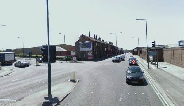
I'd never seen this photo before, and I don't think I'd recognise it even though I know the area as it is today
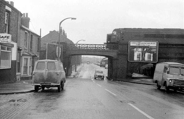
And today it looks like this
-
Nickname for someone with big tabs...
Radar tabs
-
Shurrup or I'll beltya tabs
-
If you want to see old bus tickets, there's a great collection of examples HERE
That has examples of old NCT, South Notts, Midland General, West Bridgford, Barton etc etc
-
So I was nearly right - it's only a small step from a ballroom to a cinema. Thanks for that
Bit of a surprise to see the thread come back to life after 5 months
-
Seems like definitely one of the originals has been reversed.
Here's the picture from 16, but flipped
And now the skyline is the same as the picture from 18
But of course you could also flip the picture from 18 and it would then match 16 in its unflipped state

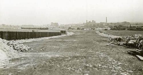
Looking at the one above with the pipe-laying, what/where are the buildings on the right? If that picture was flipped, could they be houses on the old Whitemoor bit?
-
There's THIS one which shows the same features from the other side
-
There is another photo in the same series on pictures the past Ref NTGM015117 which shows something in the background that could be Newcastle colliery. I don't know how to get it onto here.
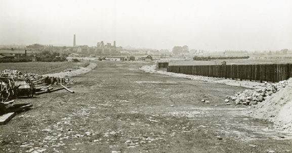
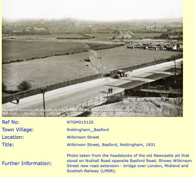
Looks like the opposite view from the photo which I started with. This seems to be looking towards Western Boulevard (if it had been built then), and a collection of chimneys and things which could be Newcastle Colliery. You can also see the point where Wilkinson Street divides just before it reaches the ring road. As was mentioned earlier, seems to have been a planned major road which didn't quite happen
-
my first thoughts were an earlier bridge but maybe part of station entrance?
I think that is possibly the answer. The road bridge at that point was modernised/enlarged in the 1930s, so maybe what you are seeing is a combination of old and new. Like THIS
If you haven't tried it, search Pic the Past with "Radford Station" and you'll see quite a few like the one above
-
As a follow-on to taxi ray's comment, it ties in with the slightly scary feature on the Old Maps website.
When you look at the various older maps on there, one of the options is to look at the Russian maps from the Cold War of the 1960s/70s, where you can see what the Communist Bloc were watching back then. Seeing a map of Nottingham in 1975 with all the street names and buildings in russian makes you wonder.
-
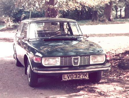
I can do that as well. I always thought they looked better with the battering ram bumpers
This was mine in the late 70s
-
The early models of Saab 99 had the Triumph 1850 engine, I know because at various times I had two of them.
The 96 was the saloon version of the 95 estate, and apparently in the early 1960s they had a Saab two-stroke engine which was later changed to the Ford V4
-
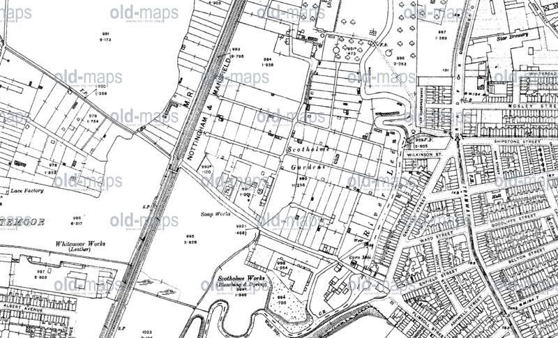
Your Gauntley Street theory seems correct, according to this in 1915.......
But it's interesting to see that there was a Wilkinson Street back then - the one we know now is obviously an extension of what was a small side-street
-
Just looked on a few old maps and you're right, Wilkinson Street didn't exist as a road before the ring road and this photo. Prior to this, the line of the road is only marked as a Foot Path through open land and allotments
And I agree, those houses are on Whitemoor Avenue, which is all that was there in those days.
I've just noticed another thing about the "mineral line" in the photo. It doesn't seem to go over Nuthall Road or get into the area in the bottom right corner of the photo. It comes into the road, then just disappears,
-
Towards the end is a car that my father had in the early 50s
It was ex forces I believe.
Can anyone tell me what it is?
http://www.britishpa...rd.php?id=13755
And what Nottingham Roads can it be seen traveling along?
I've watched it by jogging the frames along, and I reckon the first shot is Shakespeare Street outside the Fire Station; behind the car you see the garage which was the old Traffic Dept.
When they pull up and get out, I reckon that is Castle Gate, near the old Radio Trent building
And the car I think is one of THESE which is apparently a Ford WOA2
-
Looking at it again, I agree that the line in the photo doesn't match the mineral line I referred to. This one doesn't appear on any of the old maps. Was it something to do with the building of the ring road, which was obviously happening at the time?
-
I came across this picture a few days ago, and it stumped me until I worked where it was taken from.
And you can clearly see the mineral line which shows up on maps of the era
There don't seem to be any photos of Newcastle Colliery because that subject was mentioned in THIS thread from a couple of years ago, so maybe this is as close as anyone will get to it
-
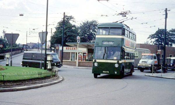
I remember the trollies coming over Church Street Bridge.
I posted this a while ago on another thread, but it's a trolleybus and it's nearly on Church Street bridge
-
I was refering to the amount of Police cover for every area at the moment, and why they can not supply the same level of resources under normal circumstances?
Isn't it to do with cost?
The Police secretly quite like this kind of thing occasionally, because they see it in terms of accumulating overtime payments. A few nights of inconvenience will pay for next years holiday, or that new conservatory.
-
I think some parents have to look to themselves and ask themselves where their kids were last night.
Totally agree with you, but the problem is that some parents don't seem to do that, whether it was last night or any other night in "normal" times. For some, the best way to bring up kids seems to be Out of Sight Out of Mind. I reckon quite a bit of minor/petty crime in general would be prevented if they kept track of their brats
-
He seems to have been the person who started the pit (although I doubt he actually did any digging). Seems he also built the first Wilford Toll Bridge
Take a look HERE and scroll down a bit
-
Drove through Beeston/Chilwell the other day and Chequers Inn on the High Road is all boarded up with a large sign saying "This pub is temporarily closed". That's a new variation on anything I've seen before
-
Mick, THIS seems to prove your memory is correct.
-
Cliff, Colliery Road was different to Queens Drive.
Prior to Clifton Bridge, Colliery Road went from Wilford Road to the power Station, as the bridge was constructed Queens Drive was extended to the Bridge.
After that, Colliery Road was between Wilford Road and Hawthorne Street. It's original name was "Clifton Colliery Road" Clifton being dropped for some reason, no idea when, just before my time.
Walsall Conduits warehouse was built on a piece of wasteland between Colliery Road and Queens Drive, at the top of Briar Street.
The history of Colliery Road/Queen's Drive is more complicated than I realised, I'm sure you're correct !
I'd forgotten the name Walsall Conduits, but now you've mentioned it I remember it being built. A minor landmark for quite a few years.
My knowledge of the area is limited to going past on a bus from Clifton in the early 60s. Looking at the second map where the line crosses Colliery Road near the place marked Sports Ground, I can remember looking at that area and seeing space where track had obviously been removed some time earlier. I'd guess it was lifted in the late 50s
Lady Bay
in Images of Nottingham
Posted
As a kid I have been on trains to London using that route but at the time I wasn't old enough to know where we were in Nottingham; I probably didn't notice that we went out of the station at the other end and went along the line through West Bridgford, Edwalton, Plumtree etc .
And this was the route where it would've been possible to watch cricket at Trent Bridge and football at City Ground from the comfort of the train for a few seconds - if you timed it right