

Cliff Ton
-
Content Count
14,701 -
Joined
-
Last visited
-
Days Won
208
Content Type
Profiles
Forums
Calendar
Posts posted by Cliff Ton
-
-
By the 1950s when the power station and the colliery were operating side by side, there was quite a network of rail lines to serve both locations
As this demonstrates.......
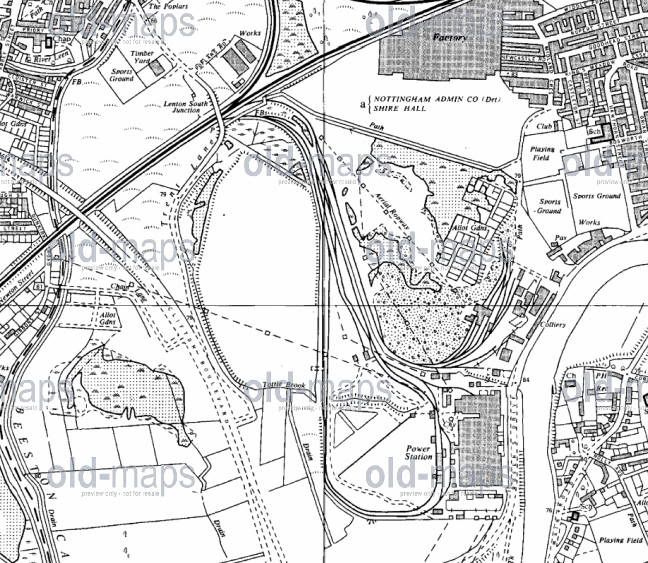
All of it's coal was moved by rail down Colliery Road and joined the rail link through what became of the large wood yard at the top of Queens Drive.
The rails crossed what became the traffic island at the top of Wilford Road. No idea when they were pulled up, but probably after the power station was built, as all coal was railed into it with some going to household coal customers.
I can remember seeing the remains of the line at the junction of Queen's Drive/ Wilford Toll Bridge, where the line went into the old GC sidings which ran alongside Queen's Drive.
THIS shows the line with the Wilford Toll Bridge behind, but the line on this photo isn't marked on the map above
-
Yes, that's the answer.
Weird confusion. Wilford Power Station was so-called because it was near the village of Wilford. Clifton Colliery (which was literally next door to the power station) was so-called because it was originally owned/operated by the Clifton family from Clifton village which is a couple of miles up the road. Its name was nothing to do with where it was.
If the same system had been used for both, they would've been Wilford Power Station and Wilford Colliery.
And now they make pork pies and pizzas where the pit was
-
Welcome, johnb-nz, you seem to be a newcomer.
If you aren't aware of it, take a look at THIS site, and in the Search section type in Wilford Power. It might bring back a few memories
I remember the place because, living on Clifton, we went past the Power Station on the bus into Nottingham.
In my earliest memories, it had six small chimneys and one big one like THIS
Then at some time in the 60s, a bigger big one was built and the six smaller ones were demolished, so it eventually looked like THIS
-
We called Goats " Nannies "
Have I missed something on this thread?
-
I reckon the biggest effect of the internet is the way you can find out almost anything at any time. Take the subjects on this forum......there is instant access to Picture the Past and the Old Maps. Before the internet it would've involved a lot of time and effort to see that material; you had to go into the Library/Archives and dig around in indexes and files for hours. Now, if you want to see what Wheeler Gate looked like in the 1920s, it takes about 20 seconds.
And think of the information which everybody has learned from the questions and answers here - we're all much cleverer than we used to be!
The internet is also useful for anorak trivia. As an example, a few weeks ago I was talking with a friend and we somehow came to wondering about the transmission dates of the first series of Monty Python. A few clicks on a mouse will provide the answer (it's the end of 1969) but before the internet that would've been almost impossible to find out.
-
A few weeks ago someone (I think it was taxiray) mentioned a new book about the history of Maid Marian Way. I've finally got a copy and it has a lot of photos I've never seen before (and also not on Picture the Past). Here's a couple of examples.
The road going left-right is Friar Lane, and you can see the gable end of the Salutation in the gap between the buildings

Granby Street, which became the top end of Maid Marian Way. The building on the right is now the Park Plaza hotel

-
Ok heres one for you.
If you were coming down Maid Marion way in 1965, and petrol showed as empty, Where was the nearest Petrol station?
I know this is going back a few weeks, but I've just found a photo which shows the answer to the question and it's a petrol station which nobody mentioned or remembered or knew about
The Astoria Garage. Junction of Greyfriar Gate and Canal Street. Opposite the Astoria Ballroom which became the Sherwood Rooms which became Ocean whatever
You can even see Maid Marian Way from their back door
-
Its about 100 yards away (just after The Swinger Pub.) Its still a garage but just one that repairs cars. it still has the semi circle drive that the trolley buses used to turn on
This one?
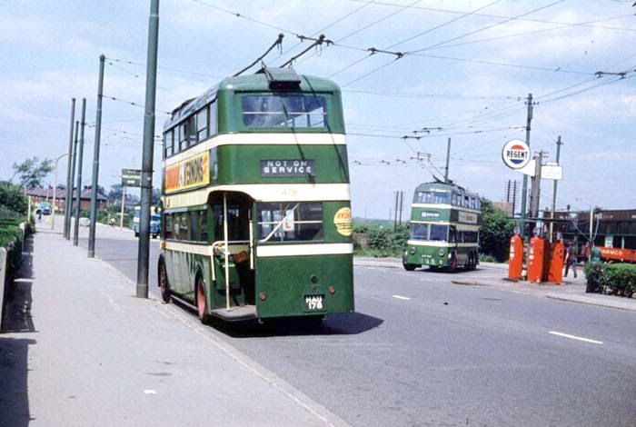
An image I've borrowed from www.trolleybus.net which has a few more Nottingham trolley photos
-
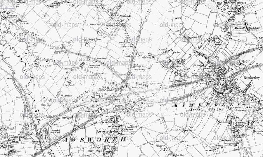
I don't really know the area so I had to look at maps to find out where everyone is talking about.
Must be some kind of record for the number of lines in such a small area
-
Not my part of the world, but nobody seems to have mentioned THIS image on Picture the Past.
-
Interesting because I'd never been aware of this line before, even though I know the area pretty well.
Many years ago I used to drive along the Gotham- Kingston road every day and never realised there had been a railway around there.
The line which I did know about was the Great Central branch which went to the Gypsum Works at Gotham, and crossed the Gotham-East Leake road on a level crossing just south of Gotham. You can still see that if you know where to look.
-
Interesting site, and the first thing I randomly came across shows a topic from a few weeks ago............a good shot of The Dive
-
I think I've worked out where we are now.
Is it this bridge?
-
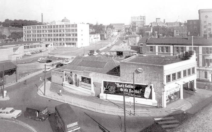
Came across this photo a few days ago. I'd forgotten THIS place ever being a petrol station, and according to Pic the Past it was still there in the mid 70s. The clock tower in the background is still there
-
I bought my first 78 in Hindleys in 1947
I bought my first 45rpm single THERE in 1967 (The Turtles - She'd rather be with me)
-
thanks for that.
It was there on the one I was looking at......I just wasn't looking in the right place!
-
I take it Pump Street St Mary iin the City is what you seek?
Are you able to post a copy of the map Ray?
A copy of such a map would be useful, because I've just looked on the Old Maps site and their 1901 large-scale version doesn't show Pump Street.
I can find Beck Street, Cross Street and Meynall Street, but there's no more detail than that. And Meynall Street hardly looks big enough to have a Platt Street and a Pump Street off it.
-
Thanks for the answers to the Pump Street query. At least that one's solved.
Now, if anybody can discover Wood Street, Basford....................
-
I'm bumping this because I still haven't discovered where Wood Street was in Basford, and it seems half my ancestors lived there in the 1860s/70s. So I'm still open to offers.
Also
I've come up with somebody's address described as "Pump Street, St Mary" which I assume means it was somewhere around St Mary's church in the Lace Market in the 1850s, but so far I haven't been able to find it
-
On 15/07/2011 at 0:32 PM, Mess said:
What a great picture!
I was at Peoples College 1966-69 and used to buy fag at the kiosk pictured. I'd quite forgotten about it till I saw the picture. Thanks for posting it
There's also another of the subject, but when it was still being built.

-
Like all genuine eccentric geniuses, he wasn't quite in the same world as most ordinary people.
He could come up with some brilliant ideas, but he also couldn't see why some things weren't quite right........

-
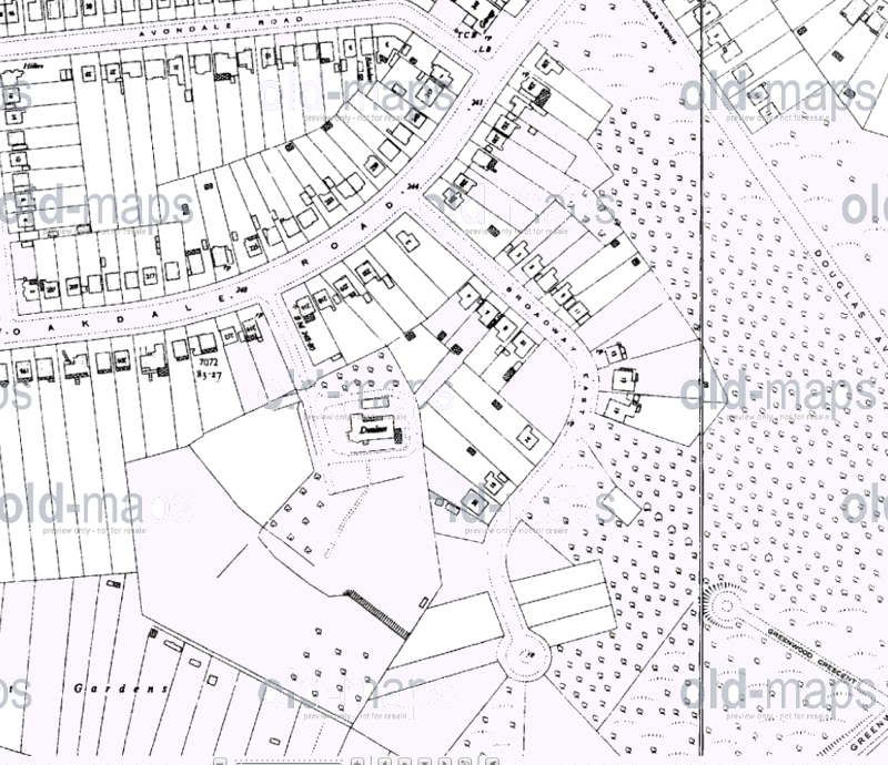
It looks like the big house that had access from Oakdale Road. This is now Poplar Close.
Thanks denshaw
Here's a close up of it. On this version you can see the place has a name but it's blurred and fuzzy, but looking on other maps I can see the place was called Dunluce if that rings any bells with anyone
-
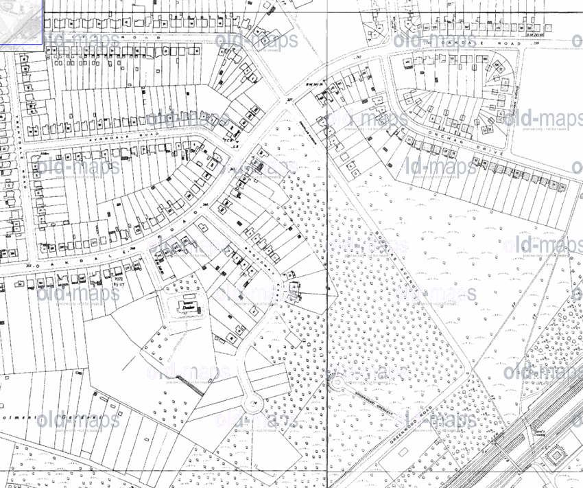
A very good friend of mine used to live on Oakdale Road, and as a child I spent a lot of time around there. There used to be a private road called The Broadway, with a large piece of land at the end of it (it was not far past the old Co-Op TV repair centre at the top of Douglas Avenue, heading in the direction of town). On the land was a house, which I believed was owned by a Doctor, but nothing can be clarified.
So, can anyone shed any light? I've looked everywhere, and even contacted the library, but there seems to be no photographs of the property or area in that time, aerial or ground, and the only name they can come across is a Doctor Saunders, but again this cannot be clarified.
I don't know the area very well but I've been following this thread, and finally i couldn't resist looking at the Old Maps site to find out what everyone's talking about.
This may be telling you what you already know, but here's a map from the early 1950s of the area in question, and I guess it shows the house you are referring to (although I don't know which one)
-
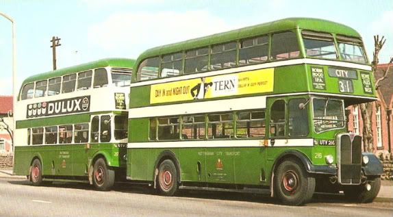
Green and cream corporation buses.
When they looked like THIS
Wilford North Power Station.
in General Chat about Nottingham
Posted
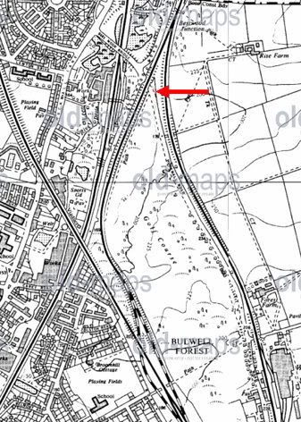
When I posted the first map I hadn't noticed it didn't show the link to the GC lines on Queens Drive (and the line which is shown on the Picture the Past photo)
so here's an earlier map which shows the line from the Colliery going across what was then known as Colliery Road - later Queen's Drive - and you can see where the photo was taken