

Cliff Ton
-
Content Count
14,694 -
Joined
-
Last visited
-
Days Won
207
Content Type
Profiles
Forums
Calendar
Posts posted by Cliff Ton
-
-
Here's an enlargement of it, then you'll see where it is on the original
-
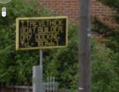
Trevethick's seem to survive in some form, even if only in name.
Look at THIS from Streetview on Lenton Lane. The road is called Clayton's Drive, but the (old-looking) sign on the front definitely keeps the Trevethick name going
-
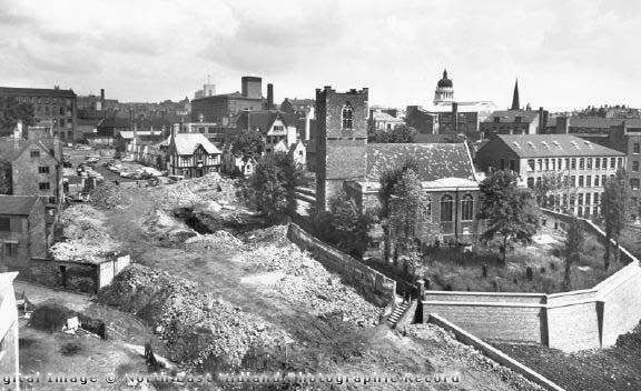
This combines two topics in one picture. Digging around for pictures of Maid Marion Way, I came across this one which I'd never seen before.
It's sort of Maid Marion Way before it was built, and you can get your bearings on it because the Royal Children is the white-roofed building in the left-centre; probably at about the same time as the Youtube film was taken
-
On 07/07/2011 at 1:10 PM, mick2me said:
Re the shop, looking at a blow up, its not clear but it may be Prestons as the shop that was knocked down top of Maid Marion way?
Take a look at THIS picture, and look at the bit where there is a clock on the wall (towards the right side). You can see the same clock - at right angles - on the small picture from the book
On 07/07/2011 at 1:10 PM, mick2me said:Re your picture Cliff.
Is that the back of the ABC Cinema on the right?
Granby Street, I have memories of there being a Granby St in Nottingham, but its not on any map now?
That building looks very similar to the Silver Knight, but it was not on the corner when I remember it, it was about halfay up towards the junction with Parliamen Street on the right.
Whats the large building on the left of the picture?
Perhaps when this was knocked down the cafe was moved further up?
Yes, that's the old ABC on the right.
The photographer was standing in the middle of Granby Street/early Maid Marion Way - where the traffic islands are - and the road going off to the right is the bottom half of Mount Street
The building on the left was apparently called the Midland Design Centre, and was only around for a few years
-
I'm a bit confused now. The photo above from the new book is a building - demolished in the 60s - which used to be at the top of Chapel Bar.
The mystery cafe was
On 04/07/2011 at 8:53 AM, mick2me said:a little further down Maid Marion Way showing the 'Silver Knight Grill'? (As mentioned in Food for Thought)
The nearest old equivalent to the top end of Maid Marion Way was Granby Street, and there was a single-storey cafe on the corner of Granby Street and Mount Street which might fit the bill. The building with "Capstan" on the front, and seems to be called the ".....something.... Cafeteria"

-
Selectadisc unfortunately closed down a few years ago, due to the fact that kids now go for downloading - if they are interested in music at all.
So if you are looking for something a bit obscure or rare, there aren't any shops left for that kind of thing. That side of things seems to have gone online.
-
If you want to buy a lot of CDs for not much money, especially reissues and compilations, go to Fopp on Queen Street - just off the Market Square
-
Whatever happened to Skill's mystery tours?
I think you've answered your own question!
Whatever happened to them is the mystery

-
I remember I used to get a newly-opened box of whatever cereal, and empty them all out into a bowl so that I could get at the free gift which would be lying at the bottom of the box.
No chance of me waiting till we'd worked our way down the contents and eaten them first
-
On 04/07/2011 at 8:53 AM, mick2me said:
Thanks Cliff.
I dont suppose you have an image a little further down Maid Marion Way showing the 'Silver Knight Grill'? (As mentioned in Food for Thought)
Not a place I remember, although maybe I went past it when I was young without knowing what it was.
Digging around Pic the Past there's one photo which might show it (although I don't really know what I'm looking for)
The white L-shaped building here ....... although it looks more like a builders hut.

-
Bournmouth had a turntable at Christchurch. The crew had to push it round.
Imagine the Health & Safety Police coming across THIS today
-
Here's a few Buses in Nottingham
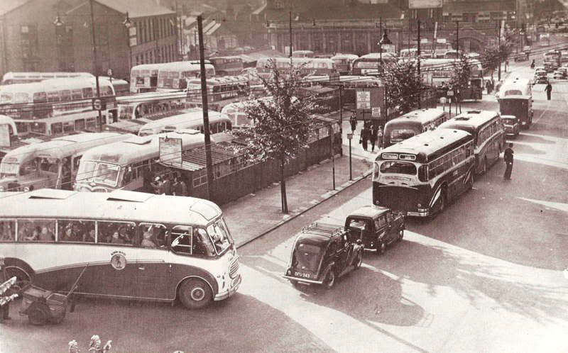
Huntingdon Street in the mid 1950s
-
 2
2
-
-
Must've been past there a few times on the bus on the way to my grandmas, but I don't remember ever noticing it.
Didn't Skills also have a toyshop in West End Arcade, and maybe even the old Central Market?
-
and I see I have forgotten the South Notts from Broad Marsh.
And a few South Notts services also went from Huntingdon Street - the routes to Loughborough/Gotham/East Leake
Do you remember the old single decker converted to a tea bar that the Corporation Transport parked at the Trent Bridge terminus?
THIS one?
-
I'm going for the record in the greatest number of answers to questions in one post.
On 03/07/2011 at 9:46 AM, mick2me said:Raises more questions, on the map what is the wording on the corner part of the coop (I worked there as electriciam 60/70s)
Fynger beat me to the answer on that one
On 03/07/2011 at 9:46 AM, mick2me said:Is that a bartons bus, what is the motor bus entering chapel bar?
Looking at the original in the book I've lifted it from, yes it's a Barton single decker. The double decker going the other way is an Atlantean operated by Trent. The caption in the book says The Albert Hall Institute can be seen to the rear of the Skills Booking Office but I can't make that one out. The left edge of the photo is too dark to be clear.
On 03/07/2011 at 9:46 AM, mick2me said:On the map can be seen the Coop Garage/Car dealership, What was it called, I am sure it had a name other than Coop?

That's the extent of the photo and it seems to be called Chapel Bar Garage
-
On 02/07/2011 at 4:24 PM, mick2me said:
I remember travelling on the 43 Trolly bus DOWN Derby road and straight across on to Chapel bar
Like this...............

Same viewpoint as the earlier photo but turned 180 degrees
-
I must've been along that road loads of times in the early 60s but I can't remember it at all now. Here's a slightly different angle on the same location, with a wider view and the other side of the road

And I don't remember Sign Of Four being in that location, but as Ashley has mentioned, I remember it being somewhere around Goldsmith Street near the old Selectadisc. As this photo shows.

-
Quite clearly the single track on the extreme right is the beginning of the descent to the 'dive'.
It's commencement was beneath the station overbridge, and features on #55.
The lower line, which turned off parallel, led to the headshunt.
Have a look at post 75 where I added a map. You can just see the features mentioned above
-
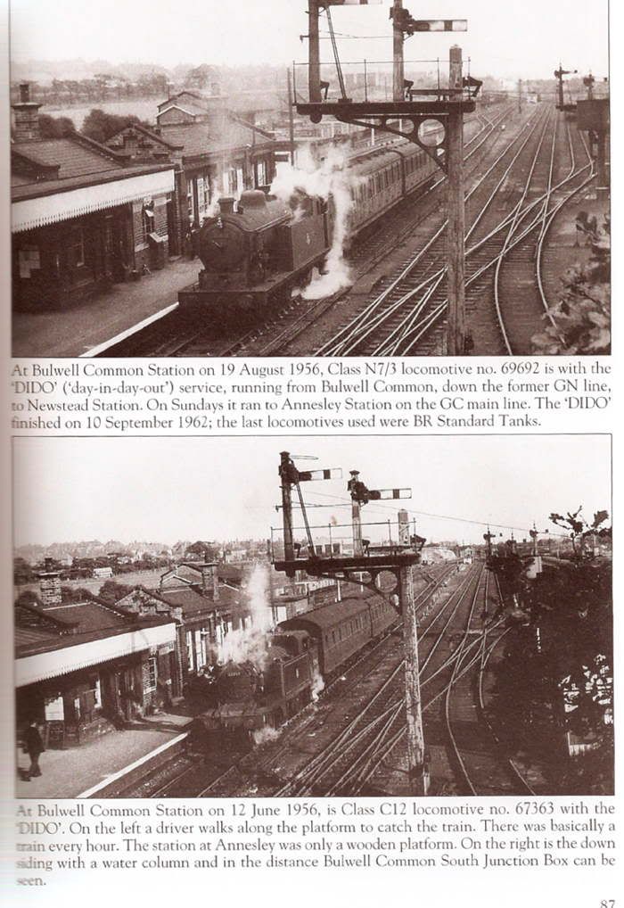
Locos I remember were C12 67363 and N7 69651 & 69695. The last one I can remember was standard 84007, but there were others including LMS Ivatt 2-6-2T's.
Someone even took photos of them and they are both on the same page of a book. I've left the text in to save me trying to explain the technicalities which I don't understand
-
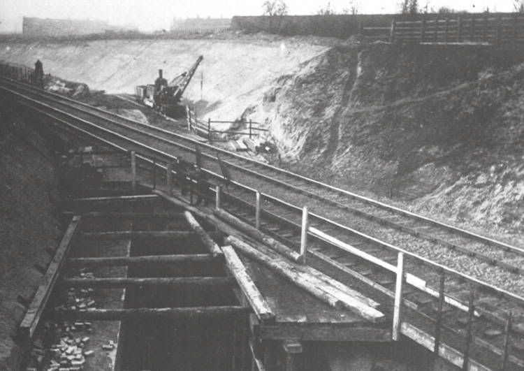
Back to everybody's favourite subject.........
Digging around in a book I'd forgotten about, I came across this which I don't think has been posted here before.
The construction of the Rat Hole
-
Not sure about it being the LNER or whatever (Pic the Past can be wrong) but isn't that the bridge which used to cross Coventry Road HERE
The cottages which stick out in the road on the right show up on Old Maps
-
I think you're mistaken here Cliff. The dive is still there, as between the hills you can just see a goods train on the main line and the top corner of the bridge over the dive.
And I think you're right. I can see what you're referring to; the rock formation in the photo is simply what is in the other half of the dive.
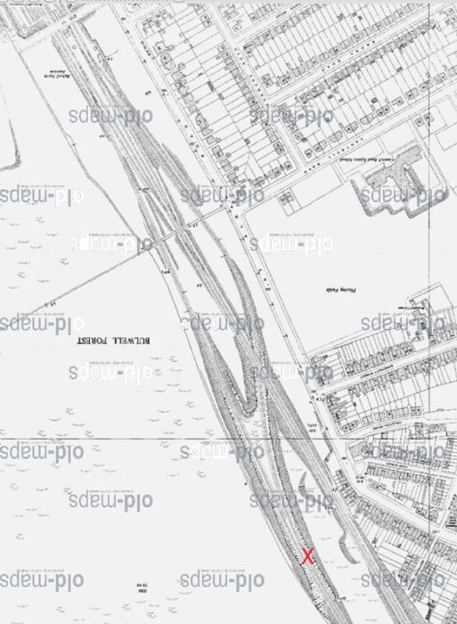
I've marked what I reckon is the camera position on this map. The main line looks further away on the photo than it does on the map !. And more rocks than I would've expected.
-
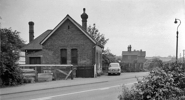
Rob, I knew where Bestwood Station was, (though nowhere near the A610? lol) just never saw it in use or a photo of it, Remember for years the station building at road level stood either derelict or part converted to a house,
I don't know the area at all, but I'd remembered seeing THIS photo, which I assume is the place you're talking about
when I explored the dive area long after your photo was taken I'm pretty sure the brick retaining walls seen in the nnsc photo were still there? also on that photo the main line embankments appear a lot lower than on your photo? though that may be different camera angles?
I agree about the embankments looking higher. Only thing I can suggest is that sometimes on demolition sites they pile stuff up high before they cart it off (I'm not an expert on it); so maybe those very high mounds of earth are actually higher than the running lines ever were
-
Going for a record?
in General Chat about Nottingham
Posted
By quite a long way, this is the greatest number of threads active since I've been looking here
Never seen it go to 2 pages before
Has nobody got anything better to do, or is everybody just hyperactive?