

Cliff Ton
-
Content Count
14,694 -
Joined
-
Last visited
-
Days Won
208
Content Type
Profiles
Forums
Calendar
Posts posted by Cliff Ton
-
-
Also, somewhere within the controls of your printer you should be able to print a test page, which will show if all the colours and other functions are working correctly
-
If you include everything which was recorded by Central/Carlton during its time at Lenton Lane, there's a helluva lot of programmes which were recorded in Nottingham
Are you just thinking of outside location work where you can see recognisable streets and buildings,
Connie, Boon have been mentioned. There was Peak Practice - not actually located in Nottingham but produced from Lenton Lane. Auf Wiedersehn Pet ended up here, and The Bretts which no-one remembers
If you include studio-based work there were game-shows such as Blockbusters, Price is Right, Supermarket Sweep, Bullseye, Family Fortunes and a whole pile of kids programmes wnich were broadcast around 4-6pm before CITV was invented
-
The one which immediately comes to mind is the old Great Northern station on London Road, aka LOW LEVEL Station
Being a gym at least means it hasn't been ruined or demolished
-
Almost as bad as the new Trinity Square
-
It's not even Mansfield Road(but Milton Street.) Mansfield Road begins at the junction of Shakespeare Street
In fact, bearing in mind the age of the photo, a lot of what is shown is actually Melbourne Street which was mentioned in THIS thread a few months ago
-
I don't know the area well so maybe someone can confirm that, but it doesn't show up on Google or Bing Maps
But they both show a Nelson Street in Long Eaton, and Bing - but not Google - shows a Nelson Street in the old Sneinton Market area
-
Digging around with family history again, and I've come across relatives who lived in Wood Street, Basford and Nelson Street, Basford around the 1880s
Neither of those roads seem to exist now, and I've looked around on the Old Maps site but can't see them (although there still is an Elson Street in Basford)
If you Google them, they both come up in references to someone else's family history, but it doesn't tell you where they were
-
That's the one I was referring to in the photo which I linked to.
It had two entrance/exits. The one which is shown here, and another one round the corner on the left on Canal Street - you'd see the other one if you could see further to the left of the "..URTIS" sign
The whole place was an L-shape from Canal Street to Carrington Street.
You can also see that layout if you look on the Old Maps site
-
THIS photo is 1978, but back around 1965 the building on the left (here it's a Job Centre) used to be a petrol station.
-
 1
1
-
-
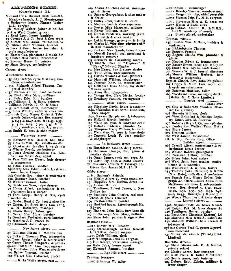
Can you do a list of the shops ????
Here we go.
It might be a bit too old to bring back memories for people who are still around today
-
If taxiray can't do a list of a shops, I'll do one because I reckon I have the same map with the list
-
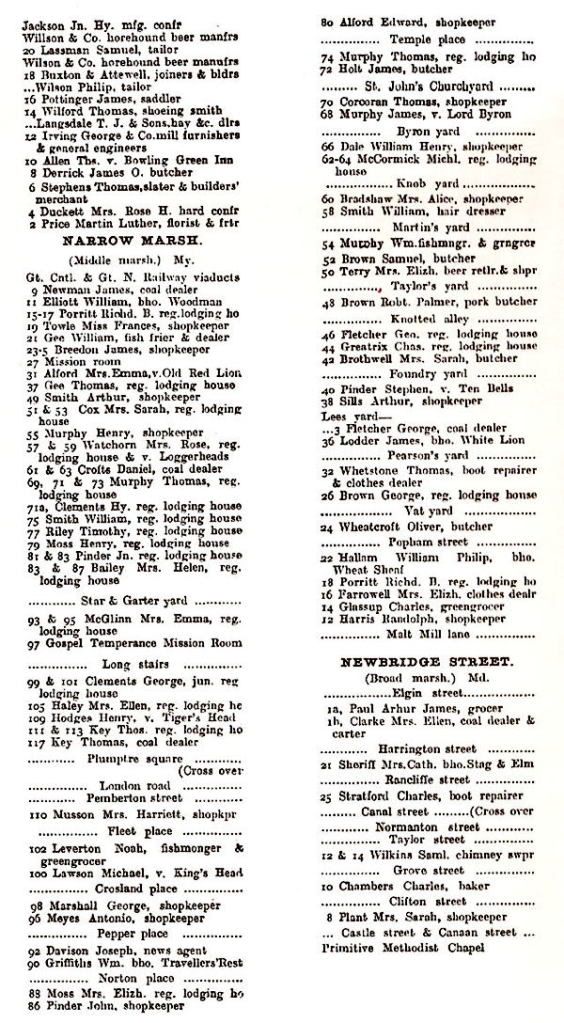
Starr lane was the first 2 or 3 hundred yards of commercial road
With nothing better to do on a wet Sunday morning, I've just looked at the Old Maps site and none of the maps for any year have a reference to Star Lane at that end of Commercial Road.
Was it maybe an unofficial name which was only used by local residents, where everybody knew what you were talking about even if that wasn't its official name
-
And they still exist with a WEBSITE which provides a lot of useful links and information
And it seems they are still at Bromley House on Angel Row
-
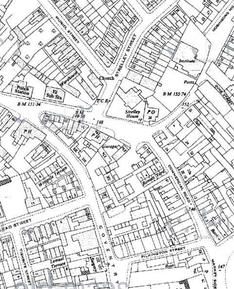
Strelley House is in the middle of here.............
But I have no idea about Fregars Garage (although there is a Garage marked across the road from Strelley House)
-
Star lane in Bulwell ran from the market up to fregars garage opposite strelley house
Ernie
Looking at old and current maps, that seems to be what is now Commercial Road.
So was it another name for Commercial Road, or was it something near there but which never seems to be shown on any maps
-
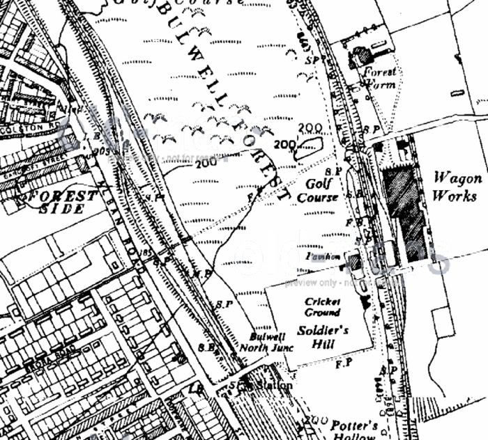
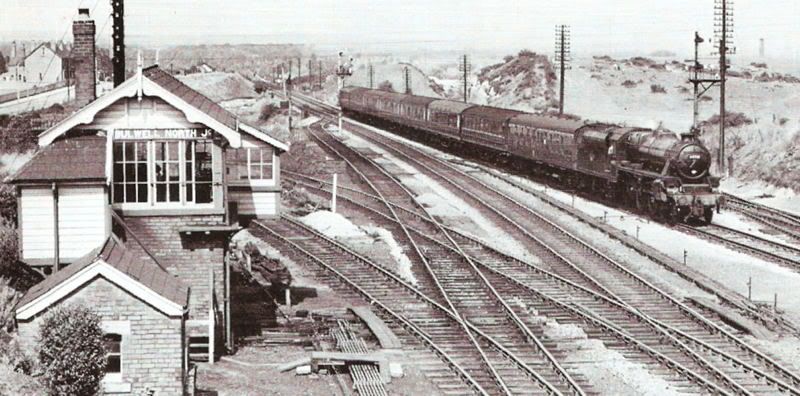
Would you say that "light strip" jutting out from behind the right of the signal box roof (just below half way) is the continuing route of the dive? there looks to be an embankment above/behind such which can't be seen in the main pic.
I'd guess that light strip is the edge of the embankment which isn't apparent on the diesel photo (although it would be to the right of the train as you look at the photo)
When I used to walk/explore the area all the bridges cuttings embankments etc were in place and the track impression could be seen in places, seem to recall the station platforms in place but no buildings, signal boxes or signals remained
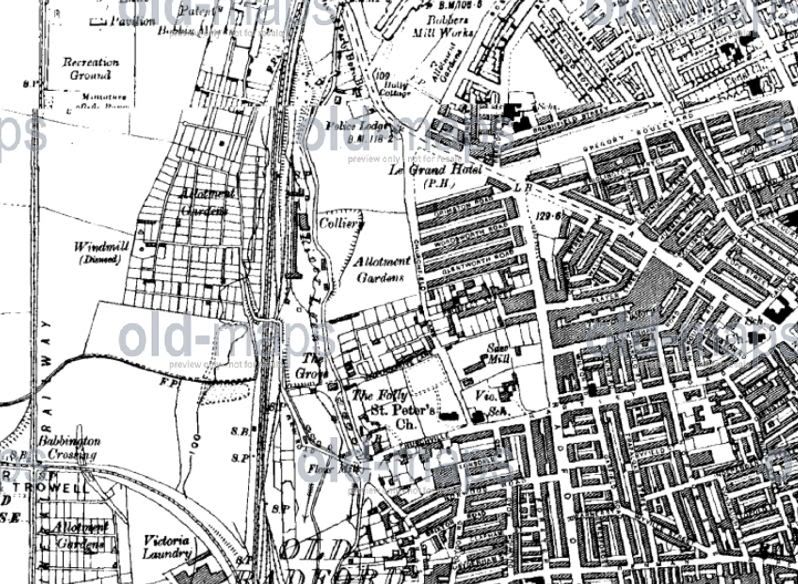
And having a look at the Old Maps shows the Signal Box and other features
-
To complete the set, because I hope this one hasn't been posted before, here's the reverse angle. The line down to the Dive is just beginning on the left.
And you can just see St Alban's Road to the left of the Signal Box
-
I also would like any info on Radford colliery particularly who was managing it and where it was plus any info on oakerthorpe colliery either the one near eastwood or the one near alfreton.
Here's a bit of help on the Radford colliery.
It also includes a reference to a disused windmill, which ties in with your other query
-
Has anyone got maps or pics of old lenton, i would like pics of the samson warehouse on castle boulevard...(i dont want any fire disaster... it burnt down sometime before ww2) and floralands which was on sherwin street... somewhere parallel to castle boulevard i think...
Lenton Times is indeed your answer to many of those questions. In particular THIS piece.
I've not heard of Floralands, although there is a Flora Cottage which still exists
Many of your other questions can be answered on Picture the Past, or the Old Maps site
-
Put the word "windmill" in the Search section of Picture the Past and you will get several hundred results.
Some of them might be just a "mill" but it's still enough to keep anyone happy for hours
-
Here is a rare picture of the Eastern End of the Rathole
Nice one, but check Post No 40 on THIS thread
-
Solved
Thanks for that. I hadn't even been looking in the Meadows area, so I wasn't likely to come across it by chance
And it appears on the Old Maps website
-
Thanks for the links. I'd Googled the name myself, but it didn't come up in the first half dozen results so I didn't look any further.
It does give some information which I didn't previously know. Looking at the reference numbers on the National Archives pages, I now know it was in the St Mary's district i.e. Lace Market/Broad Marsh area, so I'll do some more digging.
There may have been a name change after the war(s)?
That would explain why Hitler Street didn't last long
-
Doing a bit of family history research, and I've come across someone who lived at Berlin Terrace in 1911.
I've never heard of it before, and I don't think it still exists.
I've no idea which part of Nottingham it might've been, only that it was there in 1911.
Any suggestions?
Railway Photos
in Pete's Nottingham Transport Forum
Posted
And here's the Bulwell dive from the opposite side, but also when it was in a half-dismantled state
This is looking south, and you can just see the bridge of Bulwell Common Station in the distance.
The train here has just come out of the dive - except that it isn't really a dive any more because the embankment it used to go under is no longer there.
The GC main line was on the two big embankments which have been half removed