

Cliff Ton
-
Content Count
14,691 -
Joined
-
Last visited
-
Days Won
207
Content Type
Profiles
Forums
Calendar
Posts posted by Cliff Ton
-
-
Interesting that you say Beeston used to have 3 cinemas.
I don't know much about old Beeston, and I don't have any memories of its cinemas, but I'd always assumed that THIS place used to be a cinema.
Just because it looks like one. But maybe it wasn't.
-
Yes, that is the Mansfield Road end of the old racecourse. I think it closed down/stopped being used around 1890-1900
Which seems to be backed up by the information on HERE
-
Why is the Forest on the right hand side of Mansfield Road?
The wider view of the map gives the answer to that
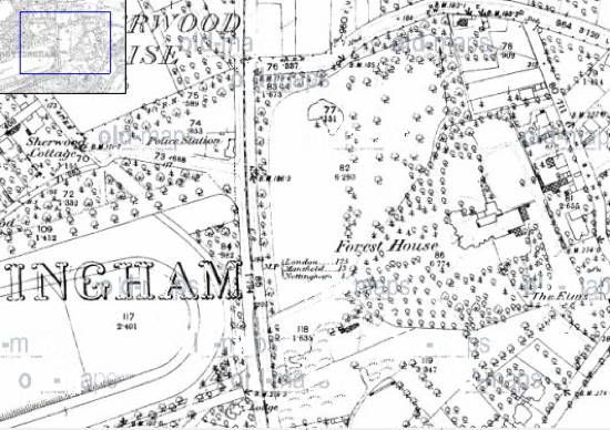
Apparently it's the big old house which became the Children's Hospital on Chestnut Grove
-
I hadn't noticed it at the time, but yes it does seem to be a Miniature Rifle Range
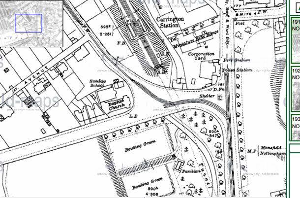
So I went back to look at the earlier versions of the map, and the 1901 version is interesting because the Police Station is in a different place
That's what is ususally known as the Station House.
So was that building originally a Police Station, which became Carrington Station entrance when the railway appeared, and the Police Station moved round the corner (see the 1920s map)
Or are the captions wrong somewhere?
-
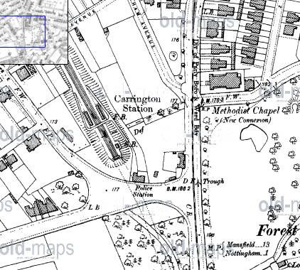
Had a look around on the Old Maps website, and maybe this will answer a few questions
From the 1920s.
On the original photo in Post 10 of the single deck trolleybus, the scenery there would fit this map, I reckon
And on Post 24 with the snowy trolleybus, the original caption on Picture the Past says "the building on the extreme left was a Police Station"......which is marked on the map
-
is that a bus in the background?
If anything, that looks to me like a tram; the upper front end is very rounded.
That would back up what rob237 says, that the picture is earlier than 53
-
Just looked at the original on Pic the Past
Looking at the two cars on the left of the photo, alongside them is a small petrol station and two old-style pumps
I didn't know that area in those days, but maybe someone else can use that feature to identify the location
-
I think the pub which still stands at the foot of Mansfield Road next to the Victoria Centre also had the name 'The Regent' at one time. Maybe in the 1970s'.
I'd missed this thread when it was originally doing the rounds, but I used to go in that pub quite a lot in the late 70s/early 80s and it went through a number of names.
In the late 70s it was indeed "The Regent", a typical slightly old-fashioned anonymous city centre pub.
In the early 80s it had an awful makeover to became "Blueberry's", with flashing lights, chrome and steel. Thankfully that only lasted a few years and it then became "Ledgers" which turned it into a kind of dusty, old fashioned, Dickensian office. That was a failure, and I've never been in it since then, but I know it's changed a few more times since then.
-
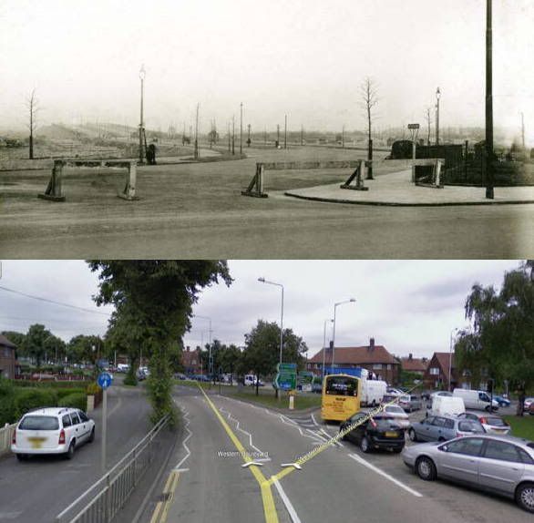
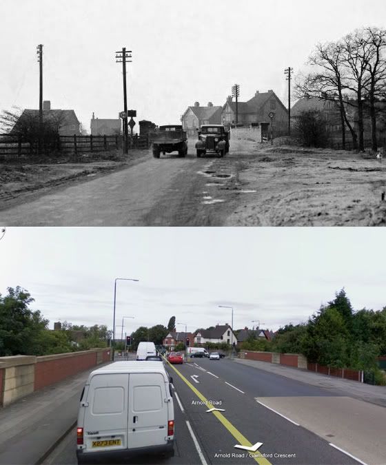
In the thread about old railway tunnels I posted an old photo of the Arnold Road/Hucknall Road junction, and then compared it with the present day.
Because I was quiet at work this afternoon I've done another, using a combination of Picture the Past and Google. Maybe an even bigger difference in the scenery; this time the ring road at Crown Island. If you can't position it, the Crown pub is on the immediate left
-
Re: the confusion about which bridge is being widened
When I first posted the photo of a bridge being widened, I thought that was the same bridge as in my two comparison pictures.
But if you look at the widening photo again, there are TWO different bridges in that photo - there's the one in the foreground which is being worked on, and there is another bridge in the background which is the one in the old photo.
So I was half correct.
-
They must have widened that bridge.
There's a PHOTO for everything
-
Not really a picture of a tunnel, or even a railway, but a stretch of road and a bridge. The junction of Arnold Road and Hucknall Road close to where the famous Rathole was.
It's changed a bit since the mid 1930s - even if the houses in the background are still the same
-
 1
1
-
-
When I mentioned the bike shop on Carrington Street which I used to go to with my dad, it was this one.
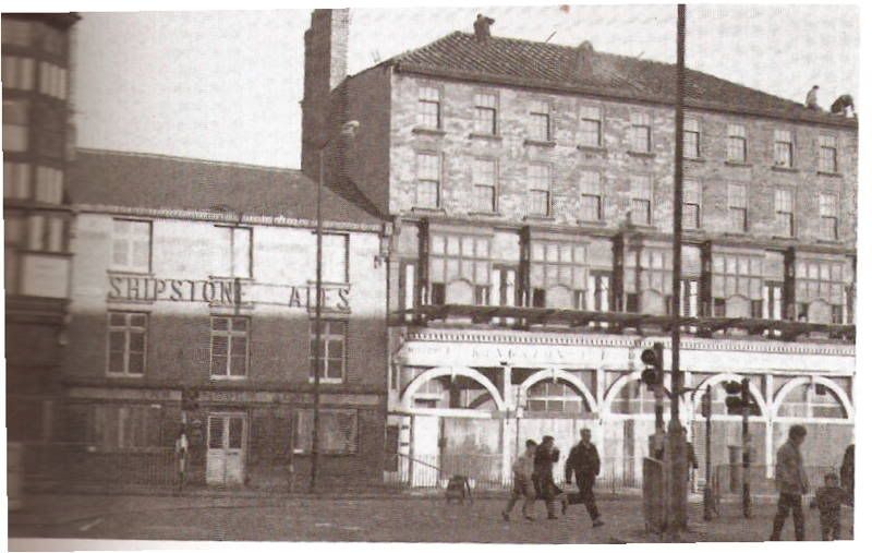
Scanned in from one of my Old Nottingham books, you can clearly see the name Kingston's across the top.
If you can't locate it; Canal Street is going left to right, and the photographer is standing on Carrington Street with the station s short distance up behind him
-
Now you've mentioned it, Dawson's and Kingston's are the ones because those names suddenly seem very familiar.
I never knew the name of the Daybrook one; we always just use to refer to it as going to "Daybrook Bridge"
It was HERE at what now seems to be a big pet shop. I can position it because if you go up towards B&Q you can still see bits of the old railway embankments, which eventually lead to the bridge over the road
-
If you have a thing about old railways, this is definitely the right place to come.
It might also help if you are an ex-biker, live in the USA, used to live in the Medders, can remember which school you went to, and can identify obscure old photos.
-
I'm not a biker and I've never owned a bike, but my dad always had one so I grew up seeing them around.
He wasn't a biker in the way of most people on this site, he was just a man who went to work on a motorbike. The other bikers here probably all knew somebody like that.
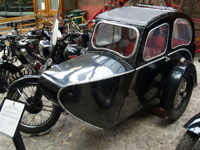
And as a kid I saw a lot of this region from the windows of a sidecar. Names like Busmar and Carmobile come to mind. Looking at them now they must've been death traps – a plywood box on a pram chassis. THIS kind of thing.
I remember on a Sunday morning (early 60s) my dad would go round various bike dealers just to wander around and look at the stuff on display and I'd usually go with him. I can still remember the atmosphere/noise/smell of those places. So I was a kid, probably rubbing shoulders with other people on this site when they were all 40 years younger.
Places I remember we went to were the bike dealer at Daybrook, next to the old railway bridge on Mansfield Road (can't remember their name). The one on Shakespeare Street near the fire station – main entrance was on Shakespeare Street but there was a small side entrance on Church Street. And the one on Carrington Street near Broad Marsh.
-
The thing which struck me about the photo is that all the doorsteps look very bright and shiny. Were they made from a different material which is a lighter colour, or is it a trick of the light from the camera, or were the housewives on that street over-efficient in their step-scrubbing?
On the subject of corner shops which aren't, these days Radford and Sneinton are full of buildings like that. Every corner in those places has an ex-shop. Some of them still have the big plate glass window in place with just a net curtain over it and god-knows-who living behind it; others have wooden boards over the space where the window used to be, and the board will be covered in graffiti or "street art".
Has everything gone round full circle. Were corner shops built as corner shops, or were they originally houses which were converted to become a shop? (not a trick question)
-
Any clues or vague ideas?
Is it central-ish Nottingham, or could it be suburbs?
-
I'll be slightly greedy and have more than one
Back to a year when Robin Hood was around (?!) and Nottingham Castle was a real working castle
And back - not quite so far - to the year I was born to see what the world looked like then.
-
 1
1
-
-
Gaffa are playing tonight at Nottm Contemporary
I was aware of them in their old days but I never saw them back then.
But I went the gig at the Contemporary.......never seen so much grey hair in one room
-
That old station building was demolished a few years ago.
If you look at THIS LINK, you'll see where it used to be (if you see what I mean)
The three-storey modern building in the centre is roughly now in the same place
-
Aup, I found this site by trying to find pic's of an old street I used to live on.
Teresa.
So don't keep us in suspense.....which street was it that you used to live on?
-
Or are you referring to the one on Park Avenue, off Mapperley Road?
-
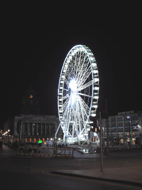
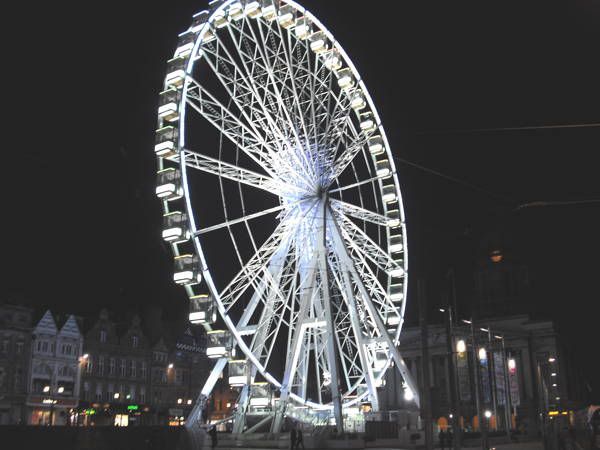
Just happened to be passing the Market Square yesterday evening and I was a bit surprised to see the big wheel is back on one of its visits, and I don't think it's been mentioned anywhere on these forums.
People who haven't been into the city centre for a few years (or haven't even been in this country for a few years) might be surprised to find something as spectacular as this.
So here's a couple of photos I grabbed on my cheap pocket camera.
Pubs closing or closed down
in General Chat about Nottingham
Posted
That's only happened within the last couple of days. Always seemed to be pretty busy with a mixture of locals and students.
Sudden closures like that often mean some kind of dodgy activities/dealings might've been going on.