

Cliff Ton
-
Content Count
14,689 -
Joined
-
Last visited
-
Days Won
206
Content Type
Profiles
Forums
Calendar
Posts posted by Cliff Ton
-
-
Not a pub I miss, because I never went in it - but a pub which isn't there any longer and I'm curious about it. It was in Vic Centre when the Centre was first built.
There is a pedestrian bridge which goes over Parliament Street (near Boots) from Clinton Street area into Vic Centre. When you've crossed the bridge from Clinton Street you go through an area which just has wall panels all the way along, until you come into the main Vic Centre area with John Lewis on your left.
I think I remember there used to be a pub along that "corridor" where the panels are now. I never went in it because I probably wasn't old enough, but it can't have lasted very long before it closed. What was it called? Are the remains of it still there behind the panels, like those ghost stations on the London Underground?
-
Is it an early version of a meet-up from few years ago?
-
...never noticed that before though...Just below Gotham is 'Paradise'???
I wonder if it's connected in some way to the location directly west of it, referred to as "Winking House"

Different topic.........I've looked all over the original map (the whole thing is called 'Vale of Trent') and there's no indication of a published date. But look at the area around Wilford and you'll see there is something marked as Elec. Sta. i.e. Wilford Power Station; and that was built in the early 1920s
-
Cliff - it was not even the A453 back then - it was a country lane. The first revision was making the road from the power station to the M1 roundabout at Kegworth, so you didn't have to drive through Kegworth to get to the plant. The story at the time was that they built the road in order to get the transformers (built in Loughborough) into the plant! At that time, the A453 still ran through Castle Donington and Long Eaton!
You're absolutely right - I was forgetting the A453 used to be somewhere else. I've dug out an old map from around (I think) the 1920s and scanned in the area in question. It shows your point about the lack of direct roads to and from the site of the Power Station. Follow the road from Thrumpton to Ratcliffe to Kegworth; not exactly direct
-
Here's a photo of Marlborough Road from the excellent book.

Seeing this photo above reminded me of a few in Picture the Past which show the same line a bit further along. I know the area pretty well but most of the railway relics had gone before I took any interest.
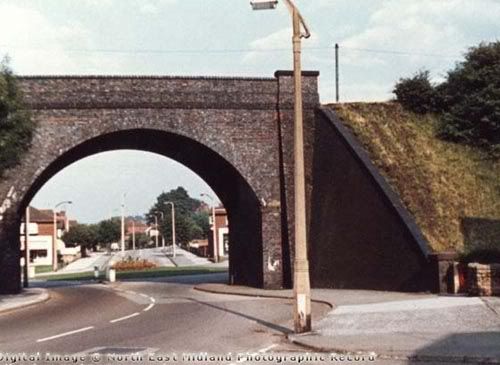
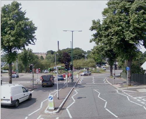
So start with the scene today, the junction of Thackerays Lane/Breck Hill Road/ Arno Vale Road/etc etc
Now the same shot when the railway bridge was still there
Same shot from a slightly different angle (Note how narrow the road is at the point right under the bridge, hardly enough space for two cars to pass)
And finally from the other side of the bridge looking towards the first two
-
I'm sure many of us remember Ratcliffe Power Station being built.
Does anybody else have memories of the place - or did you work there?
Not a direct memory, but a couple of slightly-connected memories
In the early 1960s I can remember going with my mum, dad and sister for an afternoon out/picnic and we ended up in the hilly area around Gotham Woods. I don't think I knew exactly where we were at that time, but I remember getting up to the top of the hill at the back of the woods and looking out at the massive wide view to the west, and seeing the Power Station being built over in the middle distance. It looked big even then, and it was probably only half finished.
My other memory is actually nothing to do with the Power Station, but the road it is situated on. I can just about remember when the A453, at the Clifton end, was not much more than a typical country lane. Going along there with a few friends on bikes (try doing that now) and up ahead we could see Gypsy caravans parked at the side of the road. We didn't have the courage to go past them at close quarters so we turned round and went back home. The reason we were spooked is because it was very quiet and remote, and if the gypsies had come out to grab us
 there was no-one else around. Imagine that now on the 453.
 -
Born in Bourne...grazed in Grassington...milked in Butterwick...calved in Calverton ...slaughtered in Selston:

God help anybody in Cockermouth
-
I got one. I thought it meant I was important until I read it...
-
Just having a look at Picture the Past and they've recently uploaded half a dozen aerial shots of Nottingham from 1961, which I've never seen before.
Go to their website and search for picture numbers NTGM018336 through to NTGM018341
I can just about remember when it was all like that, and it's better than looking at a map of the period
-
I don't know if it's a sign of age, or I've just become a bit pathetic, but when I first watched it a few days ago, I was looking at it very carefully to see if I was in it (during my days as a youngster, of course)
First time I've ever done that, so it's a bit scary to realise that I could now feature in old Nottingham material
-
Apologies if this has been posted before on these forums; I couldn't see it anywhere
It's pretty recent too, so you might see yourselves on it.....
-
 1
1
-
-
I reckon Picture the Past have cocked up...those pics are Hucknall Road I reckon not Edwards lane.I can't see they would move thousands of tons of stone to create the look of this modern picture.Hucknall Road looks just like those old pics just below Perry road...or would have done before road widening.Is Hucknall road in existence on that old map of yours Cliff Ton??
I've gone back to the map I used for Daybrook, and moved across a bit to Hucknall Road
Interesting that Perry Road at that stage (1900) seems to be not much more than a track.
And I agree the answer could be that Picture the Past have got it wrong. They aren't always perfect, and they can only go on what they are told by whoever provides the pictures
-
How about the bit of Hucknall Road near the junction with Perry Road..
Like this.....
It's closer to Edwards Lane
-
And now I've just raided Old Maps and come up with this 1900 version of the area, which I appreciate is similar to the one poohbear posted a few minutes ago.
But note the "Lodge" in the center of the map. That must be the building which keeps cropping up in all of these photos
-
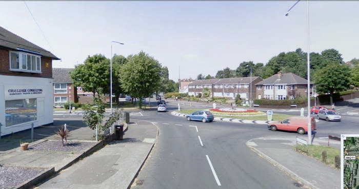
I'm wondering now.

On the old photo, the road is still going downhill, and I agree my first modern image should probably be on the other side of the roundabout going towards Bestwood
But then the current house which I though might be the same as the old one, is definitely on an up-hill; but it doesn't look far enough up the hill on the old photo
So I'm not sure of anything
-
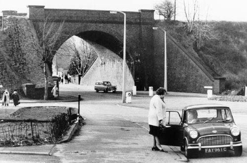
Drove down Google street, but cant identify the house.
I'd wondered..., the one on the old photo with the smoking chimney, is it this one on Google today?
It doesn't look old enough here
-
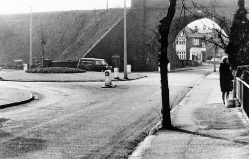
Sorry for the delay. I did it at work in a quiet moment; then work got in the way and I couldn't reply
Edwards Lane it is. Five Ways is just behind the tree on the right, ring-road goes across left to right, and City Hospital would be up ahead
As far as I can work out, this is where you'd be today.
And I know which one I'd prefer to be walking in
-
It's a nice sunny day today in the real world, and the photo in this link looks sunny and rural and idyllic.
Assuming you haven't seen it before, any ideas where it is?
The location today has changed beyond belief
-
I've got a copy of CS5 somewhere that member Frank gave me some years back.
That ain't possible, CS5 has only been available since early this year. You must have Photoshop 5 - which isn't the same thing. It gets complicated because Adobe have changed their naming system over the years.
Photoshop 1 - 7 existed from the late 1980s until 2002. Then they started calling it CS1, CS2 etc etc (Creative Suite1, Creative Suite 2 etc) because it is meant to tie in with other Adobe products. So CS1 is effectively Photoshop 8, and so on (are you still following this
?)I came to load them onto PS elements 7 and they wouldn't load!!. tried it two or three times still no joy, Uninstalled PS elements7 still no joy. I loaded them through the windows viewer, then into PS from there , at last thought I, I start to edit them, I try to use "Full Edit" and that won't load!! I tear my hair out and give up.
I think you will find that PS Elements 7 is probably too old to work on a new PC. Hence your problem
BTM..... I actually work in Graphic Design and I get paid for using Photoshop (and other stuff) in a big way, which is why I can spout all this stuff
-
I assume RAF Gamston was the later "Nottingham Airport" at Tollerton?
When I read that, I assumed it was referring to the Gamston near Retford. I don't know the area but there is clearly an old airfield nearby, as Mr Google shows :-
-
A couple of "Lucky" blokes got their numbers pulled out
Never heard it put quite that way before
-
Barbara Sharon,Gypsy Rose,Natasha French,Samantha,Stormy Daze, Della Mancinee,the Queen of Sheba,Brandy De Frank,Daughter of Darkness,Phillipa who is no longer with us,Trisha Venese,
Would it be a safe bet to assume that most of those names are not the ones they were actually born with?
-
Anyone remember the stories about the "Lion" which was reported around Tollerton in 1976. Was it a few people with over-active imaginations? Copycats jumping on a bandwagon? A slightly belated April fool?
For some reason the thread about Hollinwell made me think of this subject, and it doesn't seem to have been mentioned on this site before
I Googled around and found three references to it
Early on the morning of 29 July 1976, two milkmen saw what they insisted was a lion with a bushy-tipped tail in a field at Tollerton near Nottingham airport, prompting a fruitless big game hunt by the police. It was seen three times in succeeding days before vanishing - Fortean Times
From July 29 to August 6 1976, police and citizens searched the countryside southeast of Nottingham for a large animal described as a lion that was first reported by two milkmen at Tollerton. A total of sixty five reports were received by police , but searches turned up no evidence and no livestock was attacked - Mysterious creatures by George M Eberhan
Location: Tollerton (Nottinghamshire) - Area near airport
Date / Time: Summer 1976
Further Comments: Dozens of witnesses reported seeing a large cat that resembled a lioness, though no hard evidence was ever produced. - Paranormaldatabase.com
Or maybe the people who do crop circles, dressed as a lion
-
I wonder if you were thinking of another terminus Cliff Ton...maybe King street? Hanley Street was I'm sure only the terminus for the 1..7..and 22 which indeed travelled up Alfreton Road through Canning Circus...but then down Talbot street,and right onto Hanley street.We used to get the bus back home from there too...not just drop off point.
You're right, my mistake, I must be getting old. I meant Talbot Street, not Wollaton Street
Pub Name Wanted
in 80's Nottingham
Posted
Thanks for that one. Reading the thread all the way back there was obviously more than one pub in that area; I didn't expect the answer to the question might get so complicated. Don't think I've ever had a drink in any of them.
So is there still a ghost pub behind those panels in the upper corridor over the bridge? Or have John Lewis's expanded to fill the space?