

Oztalgian
-
Content Count
6,368 -
Joined
-
Last visited
-
Days Won
51
Content Type
Profiles
Forums
Calendar
Posts posted by Oztalgian
-
-
Compo #3860
That picture would make a terrific jigsaw puzzle.
Are the cigarette ads deliberately blurred or is it condensation in the window?
-
Thanks guys, I understand now, amazing what we learn on this site.
-
Now I am even more confused!
On that basis would a train going from Sheffield to Birmingham be on the up line? Yet a train going from Sheffield to Derby be on the down line even though it is the same line?
No wonder we cannot get the trains to run on time if we don't know if they are going up or down!
I guess its a bit like the Interstate highway system in the USA where the road is identified by the general compass direction it takes. It took me a while when travelling between Detroit and Port Huron which is north east of Detroit to work out that I had to take the I94 East
-
On the 18th January is the 40th anniversary of Australia's worst railway disaster when 83 people died and 210 were injured when a Sydney bound commuter train travelling on the up main line derailed and hit a bridge support at the Bold Street Bridge bringing the bridge down on the third and fourth carriages. It was one of the most significant events of this type of my early years in OZ
This has always puzzled me, how do you determine which is the up or down line? A google search was confusing and did not help.
I suppose that the concept of up or down varies on where you are at the time or where you are going to or from.
When going into Nottingham do you go down town or up to town?
-
Stephen,
I can recall the blind layout that you mentioned on the old AEC buses and agree that it is the most logical but can't recall ever seeing it on a Lodekka but there again as you get older some memories dim.
-
Isn't there also a bird called a Chat?
-
Colly, Pianoman, Merthyr Imp,
Thanks for the information you all provide, along with the memories and the great photos, keep them coming.
I checked with an "anorak" mate of mine and both MDT and MGO had buses with the three blinds, one showing interim stops. So much for memory!
In the case of the MDT route 208 Mansfield to Newark showing Blidworth, Southwell and Upton. Apparently the MGO inspectors were sticklers for having the blinds set properly. I think the ones with the three blinds look more pleasing to the eye. The ones with just the route number and the destination look more austere and utilitarian.
-
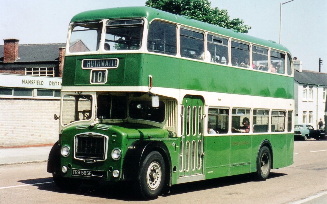
That does not look like a genuine Midland General Bus to me, as it does not have the 3rd blind that has interim stops, i.e. when bound for Nottingham the B8 blind would have shown Blidworth, Hucknall and Bestwood. This looks more a repainted Mansfield District Traction bus as shown below. Even the number plate series would fit.
-
Thanks for the advice Col,
We have just moved house and am thinking this as an option instead if the previous 5.1 sound system and the pain of installing and hiding all the speaker cables. WiFi does not seem to work too well in the room for some reason.
I will be connecting it via HDMI cables and use it mainly for Blu-Ray and DVD's.
I will take up your advice and go to a specialist Hi-Fi store where I can get a demo and model for model they are not that much more expensive that the large retailers.
Do sound bars in front of the TV block the signal of the remote as I cannot seem to find one that has a lower profile than the distance between the unit that the TV is on and the bottom of the TV screen?
-
 1
1
-
-
Hello all you audiophiles who are contributing to this thread.
I am considering purchasing a sound bar to improve the sound quality out of the TV but in reading these threads came across the expression "sound base". From the little research that I have done it appears that the sound bar often needs an additional separate bass speaker and usually sits along the front of the TV below the screen with the bass speaker, separately powered, sitting somewhere close by. I understand that the TV sits atop the sound base and that bass speakers are included. Is the weight of the TV a consideration if it sits on the sound base and is my understanding correct or are the two terms interchangeable? Thanks
-
1
-
-
I agree Red we never listened to the Scottish results anyway, never could work out how two cities could have so many teams.
Used to hate coming back from the games in the big smoke via the M1, to find a pub you used to go off the motorway into the nearest town, have a few pints and then as the designated driver having to listen to the inebriated passengers arguing about which was the best way to get back on the northbound lanes of the M1. So much easier coming back up the A1 as it still went through a number of towns in those days
-
1
-
-
Boring market town in the middle of nowhere 1 Obscure coal mining village 1
-
Comp #16
At least Forest beat Aston Vanilla 2 - nil at Villa Park that day.
A win anywhere would be good these days
-
1
-
-
Its Saturday, its 5:00pm, its Sports Report. Here are the classified football results with James Alexander Gordon
-
2
-
-
Saw this on e-Bay. Sunecta Mixed Fruit was one of my favourites. Made by R.L. Jones of Mansfield, later became Mandora.
Our local popman was Redgates Mineral Waters

-
Like mary1947#18 when we came down under in 1975 we had to do a theory test. The examiner took one look at my red British driving license that effectively said all groups, asked me which side of the road do we drive on in Australia and gave me the equivalent license here.
Having worked and driven in many countries I have learned that traffic lights in S.E. Asia and India are for decoration only.
A couple of things from elsewhere that I wish we would introduce here are - From the UK the red and amber phase on traffic lights prior to changing to green, it would improve the number of cars getting through at each change as people would be ready for the green light.
- From the USA flashing amber lights during the night and light traffic times. Flashing amber for the priority road and steady amber to give way. It avoids sitting at red lights when there is no other traffic for miles.
-
1
-
-
The useless swimming pool comparison rears its head again.
Apparently the South Australian grain harvest this year will be enough to fill 3500 Olympic sized swimming pools or 10.5 million tons.
If you tell me the tonnage I don't need the useless comparison.
-
1
-
-
Following on from comments and suggestions, with a little more persistence I have found this site which allows you to look at OS maps from different eras which might prove useful. You can even overlay them on modern satellite images. Exactly as TBI said the river was wider when viewed on the 1 inch 1955-1961 OS map and that width is where my beach used to be. Isn't t interweb brilliant.
For those that are interested this is the link
http://maps.nls.uk/geo/explore/#zoom=15&lat=53.0487&lon=-0.9003&layers=11&b=1
It is set on Fiskerton but you can search all over the UK and compare with modern images going back to the late 1800's
-
Thanks to TBI, Cliff Ton and philmayfield, who responded to my query about the "beach" at Fiskerton.
I fished there in the early sixties and remember that you paid the fee for a peg at the Bromley Arms. The "beach" was significantly lower than the path but it was only a gentle slope down to the river and no defined bank. The beach was between the end of the wall around to the dyke and the more normal bank began after the dyke. Just looked on Google earth and TBI you are right the river was wider there when I used to fish it.
Not given up yet as I would still like to find a picture of that beautiful spot from my youth.
-
I think you will find it is an oblate spheroid.
Flattened at the poles and bulging at the equator
-
1
-
-
Compo #3809
We've got one that made the journey with us when we emigrated. Still play it occasionally with Go, the travel game and Cluedo. Monopoly usually gets a run at Christmas too.
-
1
-
-
philmayfield#22
I hope you can help me with a date that the river bank changed at Fiskerton. Walking towards Nottingham along the flood protection wall outside the Bromley Arms at the end of the wall you used to go through a swing gate and on the sweeping bend there was a stretch of bank almost like a beach. I spent many hours fishing there and remember having to move your basket well back and hold on to the keep net when the John Harker barges went past creating mini tsunamis.
When I was last back I was disappointed to see that the beach was no longer there and there was only a few pegs among the vegetation. When did the bank change? I guess it was as a result of the many flood events but when. Has anyone got any photos of the "beach"?
-
Philmayfield #5
Some great memories there from a beautiful part of Nottinghamshire.
Those pub names in Southwell got me thinking and I thought that the Bramley Apple was on Westgate more towards the intersection of Appleby Rd and the road to Oxton or was that the Grapes almost at the junction.
The villages around Southwell and that part of the Trent valley seem largely unchanged over visits home over the last 40 odd years.
Narrow country lanes and great country pubs. Some that come immediately to mind are the Full Moon at Morton, The Bromley Arms at Fiskerton, Wagon and Horses at Bleasby and the pub at Hazelford Ferry which is now an aged care home?
-
1
-
-
Has the 12 Pubs of Christmas phenomena reached Nottingham yet?
It's where a group of people (sometimes quite large) get dressed in outrageously stupid Christmas gear and then have a full sized drink in 12 pubs that you can get to without driving or using public transport. There are a few rules usually made up on the go.
If you were to do this in Nottingham or any Nottinghamshire town of any era. What would your twelve pubs be in order?
From my past it would have been quite easy to do this within a short distance of Mansfield Market place in the sixties. In fact often did six pubs before going to the Palais on a Saturday night.
Bridge Tavern, Old Ramme Inn, White Hart Hotel, Swan Hotel along Bridge and Church Street
Black Swan, Victoria Hotel, Portland Arms, Railway Inn, Midland Arms, along Albert Street and up by the Station
Finish of at any one of a number of pubs near the Market Place Queens Head, Charter Arms, Crown and Anchor.
That's 12 but still plenty of alternatives in the Market Place itself Dial, Market Hotel, Kings Head, Old Blue Boar, Old Eclipse.
Estimated total distance to walk 2 miles.
The Old Market Square
in Nottingham City Centre
Posted
Great Katy,
It looked so much better as a market place, now there is an idea to revitalise a boring and sterile area.